El Chalten

 Mt Fitz Roy

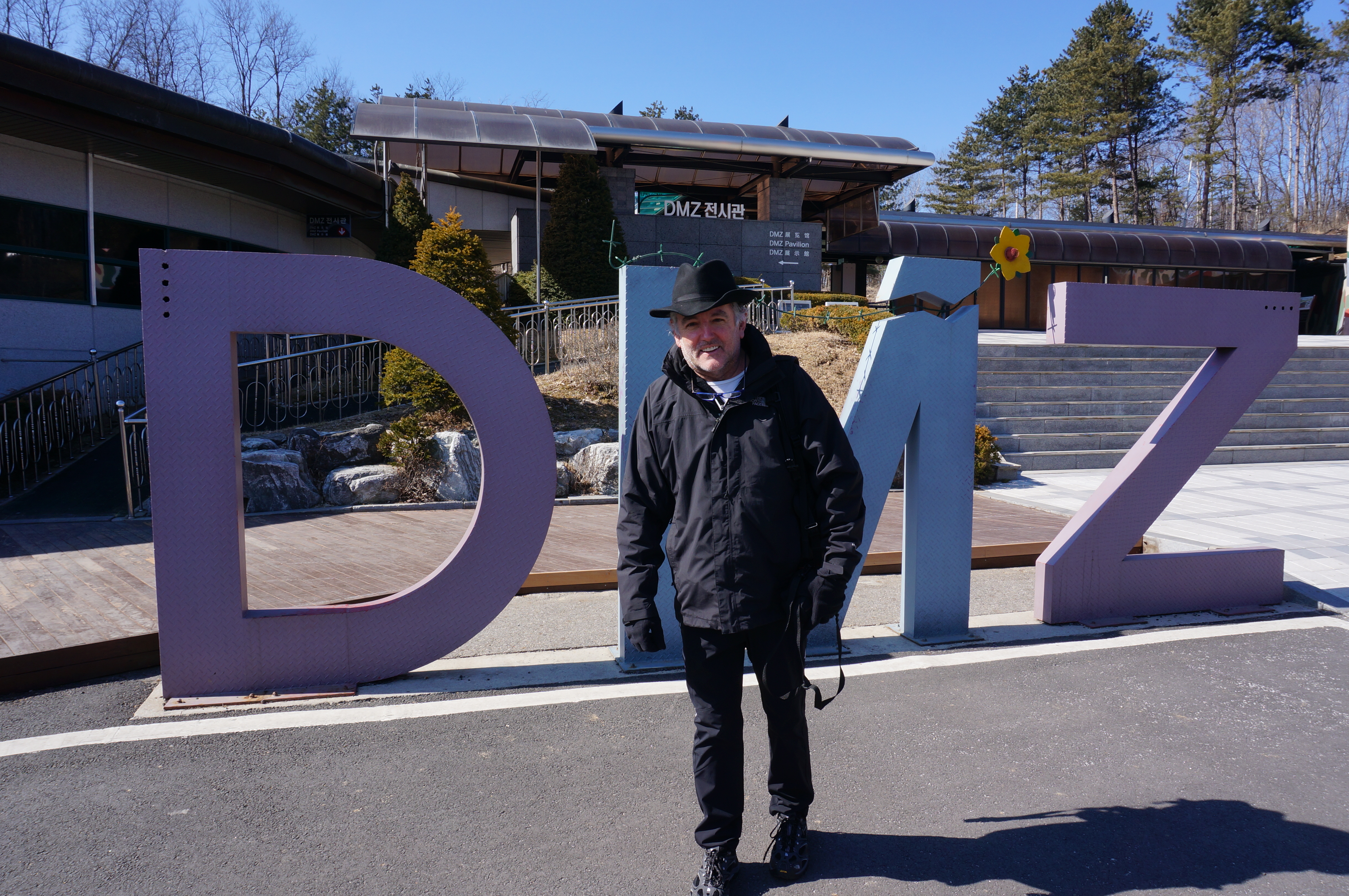
I caught the early morning bus from El Calafe to El Chalten. The road takes you past Lake Argentino and Lake Viedma. It is very spectacular countryside.

Just before entering the small town of El Chalten, the bus stopped at the National Park Visitor’s Centre. One of the Park Rangers gave a short presentation of the park and walks you can do. The weather was really good, however, the Ranger told that a change was on its way and that “if you were planning to do the Fitz Roy walk, you should do it early in morning” on the next day.

Short Walk

I checked into my hostel and headed off for a short to the south of the town. This actually took me away from Mt Fitzroy, however it provided great views over the town and back towards the mountain.

Restaurants with Wi-Fi are Popular

Back in the hostel the main topic of conversation among the guests appeared to be which restaurant in town had the best Wi-Fi. This seemed to be the major criterion to be used as to where eat rather than the quality of the food.

I found a place with Wi-Fi, however as with most places in Argentina, the speed was painfully slow.

Long Walk to Mt Fitz Roy

One of the options for getting to the base of Mt Fitz Roy was to take a min bus to the northern side of the park and walk from there. This means that you don’t retrace your steps for over 8 klms. I am not into retracing my steps.

The mini bus picked me up at 8 a.m. and did the rounds of other hostels and hotels picking up passengers before heading off.

It took about 50 minutes to get to the point where the walk starts. I headed off. It wasn’t too long before I heard a voice in South African accent say, “you are walking too slowly”. It turned to be bloke that I meet of the city bike ride in Buenos Aries. He was staying in a different hostel in El Chalten and had been taken to start of the walk on a later mini bus.

I continued the rest of the walk with the South African bloke who is in his thirties and is experienced ‘rambler’, a skill he has developed living in London for the past 15 years.

Steep Climb

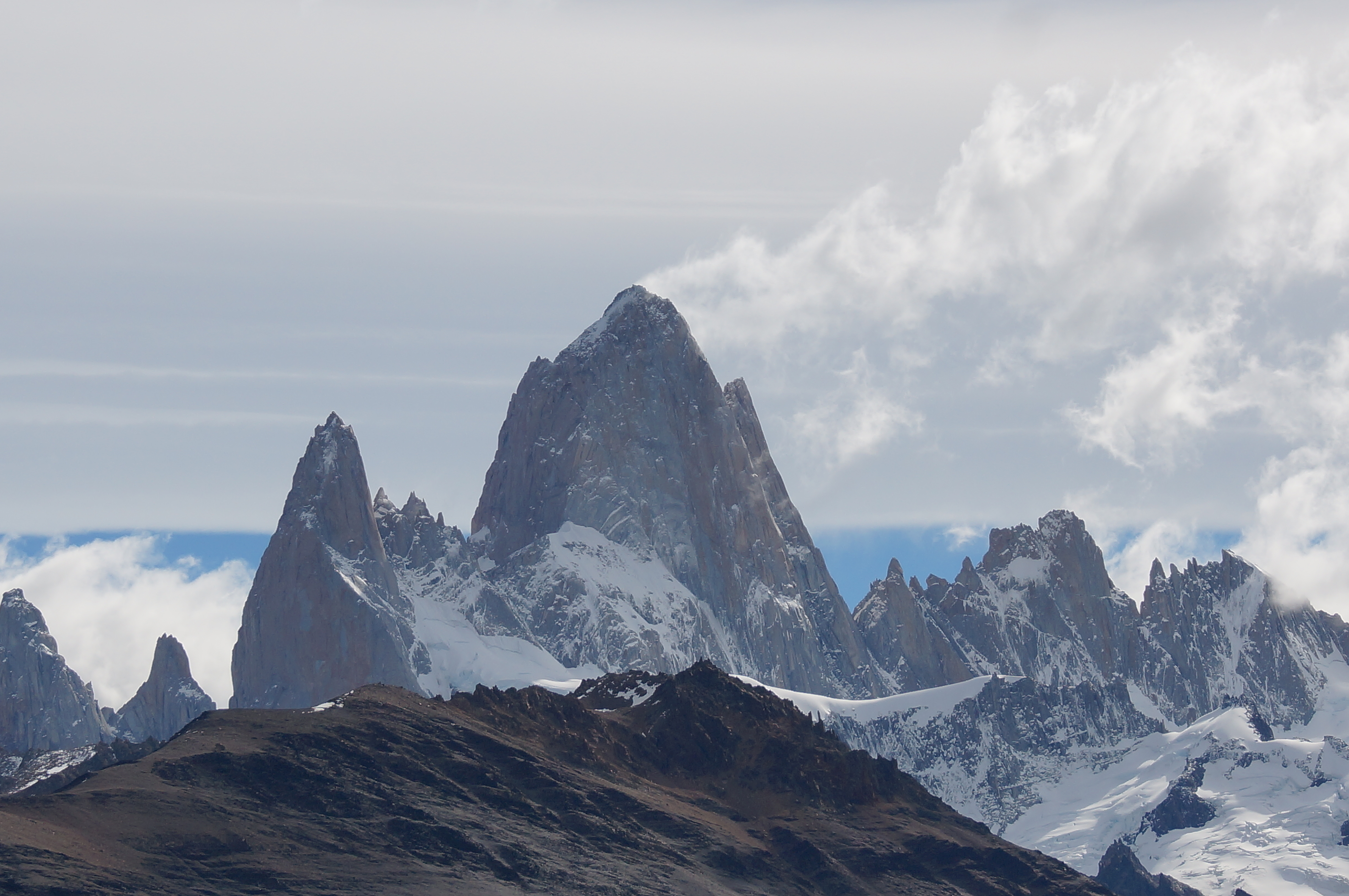
After about 6 klms walking long a valley floor, the track turned west towards the base Mt Fitz Roy. I recall the Park Ranger saying in his presentation the previous day that “the path is very steep”.  He wasn’t wrong.

The South African bloke powered ahead. I tried to keep up, but to no avail. I did notice, however, that I was overtaking people and no one was overtaking me. Having a ‘pacemaker’ does have an effect.

When I finally go to the top of the track, my ‘pacemaker’ was huddled next to a rock. It was freezing and the change, forecasted by the Park Ranger, had arrived.

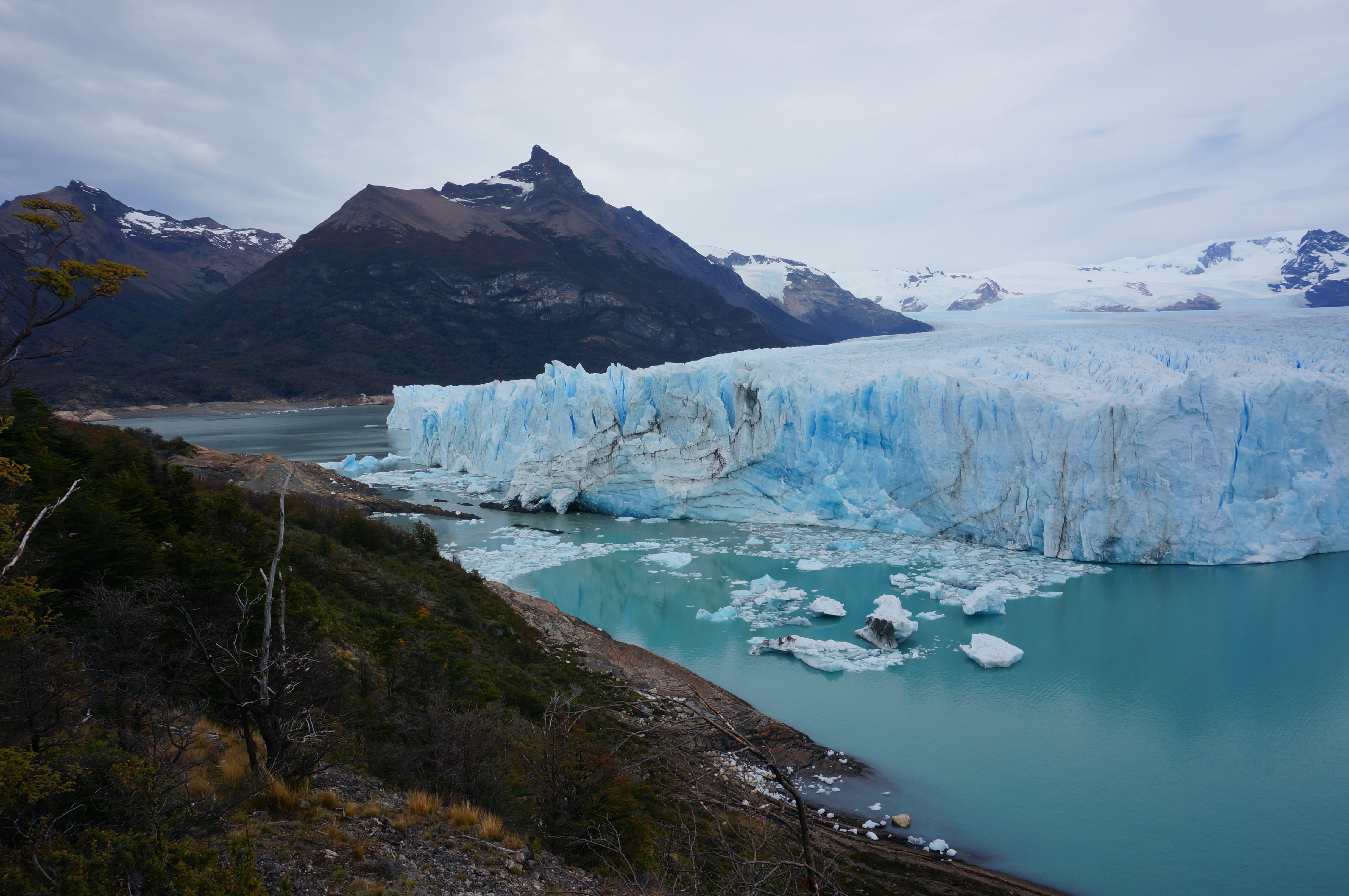
The track end at a lake of the bottom of glacier that runs off Mt Fitz Roy itself. It is very spectacular. It is a pity that the weather had turned and that it was not possible to see the whole of Mt Fitz Roy. I guess , however, that this to be expected given the amount of rainfall in this part of the world.

After a brief stop, we headed down. I actually found walking down the mountain more difficult than the climb up. The old knees are really starting to show signs of wear and tear after nearly six decades of use.

As I descended. I came across lots of people still climbing up. Some were quite old and others very over weight. I wondered when they would be get back to El Chalten.

I finally caught up to my South African ‘pacemaker’ at the bottom of the steep part of the track. By this time the wind really strong. The walk back to El Chalten seemed to go on forever. By the time we go there is was pouring with rain.

Back to El Calafate

I caught the late bus back to El Calafate. There was lot of talk among the passenger about a possible bus strike the next day.

I decided to assume that there would be no strike.

Flickr

https://flic.kr/s/aHsk6gyewJ

Garmin Link

Walk to the lake below Mt Fitz Roy. I inadvertently turned Garmin off for the walk back to El Chalten

https://connect.garmin.com/modern/activity/733896434

El Calafate

El Calafate

It is long way from Buenos Aries to El Calafate.   This required a plane trip. I had thought that I would walk up to the main avenue St Julio and catch an Airport Bus. The staff at the hostel in BA made a particular point that “you should take a taxis or hire car. I found this advice a little strange, given that I had felt safe walking the streets over the past few days.

Apparently the issue that this when you are walking the streets with a suitcase or backpack, it is obvious that you are a traveller, and likely to be a foreign tourist. As a foreigner you are likely to be carrying hard currency (USD or EUR) and would you would certainly be carrying credit cards and a passport.

The car arranged by the hostel took me to the domestic airport which is only about 15 klms from the centre of the city. Even though it a short distance, it took over 40 minutes due to the congested traffic.

Long Flight

The flight to El Calafe takes over 3 hours. That gives you an indication of the size of Argentina – it is a big place.

From the air, the area just south of BA appeared to reasonably fertile with green grass and I assume, cattle ranches.

The further south you travel the land appeared to become progressively more barren with no obvious evidence of agriculture.

As you approach El Calafate, you fly over Lake Argentina, which I was to later learn, is the largest lake in the country. It is an aqua blue colour cause by the sediment generated by the glaciers that feed into the lake.

America Del Sur Hostel

I had arranged transport from the Calafate airport into town via an email to the hostel. This turned out to be a mini bus.

The hostel has a great view of the Lake.

After checking in, I took the 10 minute walk into town. The place has to look and feel on a town near to a skiing area – a bit like Jindabyne in NSW, Bright in Victoria or Queenstown in New Zealand. How the main outdoor activity in this area is walking.

Tour to Glacier Perito Moreno

The big attraction of El Calafate is the Glacier Perito Moreno. There seemed to be any number of tour operators to the glacier. The hostel recommended a particular operator. I took their advice.

The tour was on a mini bus. This made it possible to take a gravel road along the lake rather than the main road.

At one point we stopped at small farm. The guide explained that the area around El Calafate and west to Andes was very dry. The moist air coming across the Pacific Ocean and hitting the mountains bordering Chile and Argentina, loses most of it moisture in the mountains in the form of snow. It rarely rains or snows to the east of the mountains.

The guide also told us that area had been used for sheep growing. This was reasonably successful for a while until it was realised that the sheep were destroying the land. This was due to their hard hooves and the fact that rather than cutting through the grass like scissors, they tended to rip the grass out of the ground. Over time there was less and less grass and it look ages for it to regrow. In the end the sheep growing become unviable.

The small farm that we stopped at had been turned into a guest house. The only animal were some alpacas, goats, a cat and a fox. The fox seemed to have been trained to arrive shortly after our bus.

Spectacular Glacier

After leaving the farm, it was a short drive to entrance of the National Park that includes the Glacier Perito Mareno. We were dropped off on the northern side of the glacier. This side flows directly in to the main part of Lake Argentina.

It was not long before we heard a loud crack and splash. This was piece of the glacier falling into the lake. The guide had explained that the glacier advances about 3 metre per day. It is also ‘stable’ in that it is not getting longer or shorter. All of the other glaciers in the region are getting shorter or retreating.  I guess that this is an inconvenient truth in for those that do not believe in climate change.

The Flickr photos are the best way to describe the glacier. Check out the ‘blue’.

There are series of elevated paths that take you from the northern side to a ‘point’ in about the middle and on to the southern side, of the glacier.

The ‘point’ is a piece of land, like a peninsular, that almost touches the advancing glacier. The guide had explained that periodically (2 and 8 years ago, in recent times), the glacier actually meets the peninsular and forms an ice dam between the south side of the lake and the much larger northern side. Given that the run of from the southern side of the glacier is trapped in the much smaller part of the lake, the water level rises relative to the larger northern side. This difference in the water levels and get as high as 30 metres before the pressure becomes too great and the ice dam breaks, letting the water floe from the southern side into the northern side. The guide said that the most recent ‘dam collapse’ took place at night and no one saw it.

German Girls and ‘Six Degrees of Separation’

Why walking on the paths, I got to chat with a couple of German girls that were travelling separately. One spoke with a very strong Irish accent, so strong that the other one found it difficult to believe that she was German.

It turned out that the ‘Irish’ German girl had worked as a Nanny for a friend of my ex-wife in Mosman in Sydney. I vaguely know that woman, but it is a classic case of ‘six degrees of separation’.

Boat Trip of the Lake

After wandering around the paths for a couple of hours, we were pick up by the mini bus and taken down to the Southern part of the lake where we caught boat.

The boat sailed up to 300 metres from the glacier. The Flickr photos and video tell it all.

Bike Ride

The other thing I did in El Calafate was a downhill mountain bike (MTB).   This involved taking a chairlift to a very small little ski ‘resort’ about 20 klms from town.   As noted above, the area around Calafate gets very little snow, so it is not much of a place to ski.

There were 6 people on the excursion – a couple from Norway and an American girl and myself that were doing MTB riding and 4 others that were doing Quad bike riding.

The MTB ride was from the top of the chairlift back into El Calafate.   The path was a mixture of 4 WD paths and single track.

The guide was obviously a really good rider and was the Norwegian bloke. His wife was also very good. The American girl found the going tough and pulled out after about 30 minutes and was collected by a 4WD.

There was one really tricky bit that instructor did with easy. The Norwegian bloke managed to do it but was very shaky on the run off. I decided to chicken out. Breaking a bone in this part of the world would not be a good idea.

The last part of the trail just before getting into town was a great section of single track.

The ride was well worthwhile.

After the ride I had a coffee with the Norwegian couple. They live on the Island of Spitsbergen which is almost in the Artic Circle. He works as tour guide and takes people into the Aric Circle including the North Pole. Interesting life.

Early Night

I had an early night because I was due to walk up early to catch a bus to El Chalten.

Flickr Link

https://flic.kr/s/aHsk9bRuXF

Garmin Link

https://connect.garmin.com/modern/activity/729972035

Buenos Aries

Buenos Aries

After a 24 hour delay in Sao Paulo, I finally made it into Buenos Aries. As recommended by the hostel I took a taxis into town.

Walking tour

In the morning I decided to take a walking tour offered by the hostel.

This was quite informative and took in the main sights in the main part of the town. In the square (Plaza de Mayo) in the front of the ‘Pink House’ (the Presidential Palace) the guide pointed out where the mothers of the children, which disappeared during the Military Dictatorship that governed the country between 1976 and 1983, gather. The dictatorship interned its critics. Many were killed and disappeared without trace.

Some of the ‘disappeared’ were pregnant women. Many of the children of these women were adopted by supporters of the regime. In recent times there has been a concerted effort identify these children and united them with their grandparents. This whole episode highlights how corrupt and immoral undemocratic regimes can be.

Evita Museum

At the end of the tour, the guide offered an “additional attraction”. This was the Union Offices. The significance of this building was that it where Evita Peron used to work from when she was the first Lady of Argentina up until her death in 1952.

The ‘Museum’ turned out to be two rooms, with memorabilia (mainly photos and paper clippings that were collect by a union official who actually worked in the office when Evita was still alive. He is in his late 80’s and speaks to the visitors to the ‘Museum’. His presentation was in Spanish, but effective in that he was very emotional. The guide gave a brief translations of what the old guy had said.

One of the things we learned from the old guy was that Evita’s body was held in the building for some time after her death. At some point in 1955, it was taken by the military regime that overthrew her husband Juan Domingo Peron. Apparently the body was ‘lost’ for some time until it turned up in Madrid were Juan Peron was in exile.

Evita’s body now lies in her family the Duarte family tomb in La Recoleta Cemetery. The irony is this where the rich people are buried and she is the hero of the poor.

A couple of days after visiting this museum I visited the cemetery. There are volunteers at the gate to the cemetery that sell you a map detailing the location of the tombs with the names of the families. I asked that volunteer where Evita’s tomb was. She feigned ignorance. I asked again saying the “Duarte Tomb”. Again she feigned ignorance. I suspect that this evidence that Evita is still a very controversial figure in Argentina. The current left wing president Cristina Fernandez de Kirchner evokes Evita in the presentation of her government’s policies. Her opponents are vociferous. The volunteer is clearly not a supporter of the current president.

Bike ride

I decided to take a bicycle tour of the southern part for Buenos Aries. This is the ‘dodgy’ part of the city. The tour turned out to be really good.

Boca Juniors Football

The guide was well informed and clearly had a sense of humour. The tour started near to the hostel and headed south towards the Boca area. We stopped at the stadium where the Boca Juniors soccer team plays. The guide told us that they got their blue and yellow colours from the Swedish flag. The story goes that they decided that they need a flag. One of the supporters when down to the nearby by port and took a flag off a ship. The ship happened to be Swedish.

Tango

Next stop was the ‘tourist’ bit of La Boca. This a bit contrived, but you do a feeling as to what it was like when the poor immigrants lived in this area in the early 1900’s. It is where the Tango started. The original Tango dancers were prostitutes and their customers. I had a short dance with a young lady the required payment for a photo to be taken. That was all. Check out the Flickr link.

Back into the Main Part of Town

We headed back into the main part of the city, via a park that has recently been established on the river. We also passed any new residential area which is built on the canals. Housing here is very expensive.

The route also took us into the main square. The guide gave his spin on the Evita years and the current state of Argentinian politics.

The last part of the ride was a bit hectic and we negotiated the traffic in the main part of the city. It wasn’t too dangerous as the traffic was moving so slowly.

Tour of the Palermo Park

When I returned to the hostel there was a group pf people waiting for a ‘free tour’ to the Palermo area, including the Park. I decide to join the tour.

The woman leading the tour was a teacher. She was very interesting. The first part of the tour involved a bus trip on a local commuter bus. That was interesting in itself as it was rush hour. There was a lot of ‘up close a personal’ on the bus.

We got off the as the entrance to the park area. One of the first things the guide pointed out was a planetarium. The guide told us that this was the site of a cricket ground which established by early English settlers. Overtime, they left and the Argentinians didn’t take up cricket.

As we walk through the park the guide explained that it was designed to replicate that great city parks in London. Paris and New York.

As one point we stopped for some mate tea. The link below provide more information on this drink. It isn’t my favourite.

Tigre

The next day I took a trip out to Tigre. This a town about 40 klms from Buenos Aries. It involved taking the metro to the end of the line and then a surface train. The second was packed with people going to a Music Festival. I had a brief, but interesting conversation with a Lufthansa air hostess who was going to the festival.

In hindsight I should have gone to the festival. Robert Plant (Led Zeppelin) was playing that day.

I took and ‘hop on hop off) tour of Tigre. The most interesting things were a naval museum which included a section of the Falklands (Maldives) war and the fact that the river that passed through the town was covering the roads in parts.

Cemetery and Palmero

The following day I check out the La Recoleta Cemetery. I talked about that above. I also walked around the residential and shopping area of Palmero. This is a very affluent area. It is such a contrast with the southern part of the city.

Quick trip Across to Paraguay

On my last day I decided to take a trip across to Colonia del Sacramento which is across the river from Buenos Aries.

The crossing is made on fast ferry. There is a bit of mucking around with passport control and both ends.

The town of Colonia is UNESCO heritage listed. The main reason appears to be that at various times in was occupied by the Portuguese and the Spanish. Ultimately the Spanish won out. The guide pointed out that the streets that were built by the Portuguese sloped to the middle with water draining down a channel in the middle of the road. The Spanish roads sloped away from the middle, like roads of today.

On the reasons people travel to Colonia is to get US Dollars that can be withdrawn from the ATMs. These can then be used to buy Argentinian Pesos and the black market (blue) rate that is 30% better than the official rate. People wander up and down the main street withdrawing the maximum allowable amount from each ATM.

Quick Comment

It was good to see Buenos Aries. It will interesting to see how the place changes, if at all, when the new president is elected at the end of the year.

Flickr Links

Buenos Aries

https://flic.kr/s/aHsk5TvTf6

https://flic.kr/s/aHsk5VTnEZ

https://flic.kr/s/aHskaxpoFM

BA Bike Ride

https://flic.kr/s/aHsk8QYfdC

Tigre

https://flic.kr/s/aHsk9r5UN3

Colonia

https://flic.kr/s/aHsk9TUTGr

Link to Mothers of the Disappeared

http://en.wikipedia.org/wiki/Mothers_of_the_Plaza_de_Mayo

Link to Bike Tour

http://www.babikes.com.ar/

Link to Mate Tea

http://en.wikipedia.org/wiki/Mate_(beverage)

Lightning hit Plane landing at Sao Paulo

Sao Paulo

The cheapest way to get from Seoul to Buenos Aries is via the Gulf. I guess this is simply a function of competition, with a large number of airlines flying from the SE Asian hubs – Seoul being one – to the Gulf and on to South America. There are fewer airlines flying across the Pacific.

I booked a flight with Qatar Airlines that went through Doha in Qatar. It had a 3 hours layover and transfer onto another plane before going on to Sao Paulo in Brazil and on to BA.

The first leg was fine as was that layover in Doha. We then headed off on the 14 hour leg to Sao Paulo. That took us across Africa, reaching the Atlantic Ocean south of Nigeria and on to the South American continent. There was quite a bit of turbulence going across central Africa and across the Atlantic. I guess this is to be expected if you are flying near to the equator. I have experienced several instances of severe turbulence when flying across, and near, the equator before.

Bad Weather Ahead

About an hour before we were due to land in Sao Paulo, the Captain announced that “there was bad weather ahead and that the airport at Sao Paulo had been temporarily closed for 30 minutes”. He said that there may be a delay in landing.

As we flew on, there was progressively more and more turbulence and we appeared to be constantly in cloud.   An announcement was made that we were “commencing our decent in Sao Paula” and the cabin crew started making the usual preparations. The indicator on the maps screen on the entertainment system showed that we had 20 minutes to go before landing.

Bright Flash of Light

Suddenly there was bright flash of light in the cabin that came from outside.

One of the cabin staff ran to the back of the plane (I was sitting in the last row) and picked up a phone. She then ran back to her position towards the middle of the plane. There were no more announcements and the plane appeared to be slowly descending.

’5 – 20 Minutes to Destination’ for about 40 Minutes

The indictor of the altitude of the entertainment system appeared to be all over the place. One minute it was 14,000 feet, next it was 5,000, then 20,000 and back to 5,000 feet. It the same time the plane appeared to be slowly descending. There was no visibility.

The indicator showing the ‘Time to Destination’ was similarly all over the place. It fluctuated from 10 minutes to destination, to 20 minutes, to 5 minutes and back to 20 minutes.

Finally, we were able to see land out of the windows and we obvious near the near the runway. The indicator was showing ’10 minutes to destination’.

Very Strange Landing

We appeared to be landing very quickly and hit the ground hard. The plane also wiggled from side to side.

The engines and brakes were clearly engaged as hard as possible in stopping mode.

We didn’t draw into an Air Bridge at the terminal. There was a long wait before the passengers that were due to depart the flight at Sao Paulo were told that they could leave the plane.

Shortly after those passengers had left, it was announced that the passengers that were flying on to Buenos Aries would also have to leave the plane as “there was a mechanical problem that needed to be checked”.

Long Wait in the Terminal

The passengers going on to BA were directed through the ‘transfer’ area and to a departure lounge.

Most of the passengers appeared to be Argentinians with few able to speak English. I got into conversation with a South African couple who live in Perth. The bloke seemed to know about planes.

It was his view that the “flash of light was lightning hitting the plane” and that it had “done something serious to the on-board computer”.

At 8.00 pm we were told that an announcement would be made about the flight at 11.00 p.m.   People will connections to other flights or other pressing needs to be in BA were clear distressed.

The Qatar staff confirmed that the problem with the plane was due to a “lightning strike”.

I went for a walk through the terminal. I came across another South African bloke outside the Business and First Class Lounge. He was seriously pissed off. He told me that the Qatar representative in the lounge had said “that the plane was not going anywhere tonight”. They were also “arranging for the crew to get to a hotel”. He was particularly pissed off, that the “customers appeared to be the representative’s least concern.

Fight Final Cancelled

When I got back to the gate, the other passengers were either standing around the Qatar staff asking for advice or just sitting back watching the scene.

The indicator board suddenly changed from ‘Flight Delay’ to Flight Cancelled’.

We were the led to the baggage collection and finally on to buses to the Bristol Hotel.

Checking into the Hotel

We got to the hotel about 11.45 pm. This was a real circus. There were two people at reception. The line of passengers quickly over 50 long.   It took about 10 minutes to check in.

I was lucky to be near the front of the line and was able to check in fairly quickly.   I suspect a lot of people.

I was glad to finally get horizontal.

What Happens when Lightning Strikes a Plane

Since this flight I have talked to a number of people about lightning striking planes.  One was a Lufthansa flight attendant that I met on the train to Tigre. She told me that lightning strikes are common and normal they are not a big issue.

It would appear that this not always the case.  Refer to link below.

I guess that I will never know, if the flight I was cancelled because that plane was damaged due to the lightning or the rough landing.  Also was that rough landing due to loss on control because something the lightning did or was it due to the turbulence related to the storm?

http://www.boeing.com/commercial/aeromagazine/articles/2012_q4/4/

Flickr Link

https://flic.kr/s/aHsk9p6fNz

Seoul

Seoul

I ended up staying a bit long in Seoul than expected. This is because I dallied in booking my flight to Buenos Aries. If I want to leave earlier, the cost of the flight would have been considerably more. One of the benefits of not working, is that time doesn’t matter too much.

Good Place to Stay

I stayed in small hostel near the Honjik University. This a happening little area, with lots of bars, restaurants and ‘street life’. The contrast with Japan was palpable. In many respects, the cities in Japan, even Tokyo are dour places. My immediate impression of Seoul was that it is more ‘Asian’ and more relaxed. There certainly seemed to be more young people around. If think is reflects that demographics of the place, not just that I was near universities.

Palaces

I checked out the palaces. I guess I should be more interested in ‘older’ Korean history, but after Japan, one palace started to look just like any other.

Metro Underground Railway

The Seoul metro system is impressive. Lots of lines, covering most of the city. The stations I saw, all had the dual door system – doors on the platform lining up with those on the train.

One issue though is the paper maps in the tourist guides. They cover all the network on small pieces of paper. This results in the writing being almost too small to read. There is one version on a large page. My skiing friends managed to find a tourist booth with that version.

A simple option used in other cities, e.g. London and Paris is to print a map that only includes the central part of the network where 95% plus of tourists would travel. This means that the printing is large enough for old coots like me to read.

I guess that other thing is that most people us smart phones to get around and don’t need paper maps.

Another whinge I have is that on the ‘circle line’, the indicator board on the train shows that train moving in the opposite direction to the train’s actual movement. Check out the video.

End of the whinging.

Museums

Seoul has great museums. The cultural museum has a better building than its contents (check out the photos of the aluminium sausage like thing) but was interesting. The National Museum is huge and very interesting. There was also a small museum (that can’t remember the name of) that was covered Korea’s economic development very well.

Probably the most impressive museum was that War Memorial. It has some excellent exhibits and material on the Korean War and is impact on the soldiers and the people of Korea.

Shops

This a serious shopping town. There are a lot of upmarket shops that look just like other upmarket shops in other big cities, with all the usual brands. This is a great refection on the wealth of the place, albeit these shops do nothing for me.

There is an electronic shopping centre on seven levels. I defy anyone to be unable to find the electronic gadget (phone, computer, – new or used) they want in that place.

River and National Assembly

I took a walk to and along that river from the area I was staying. It was a bit bleak, given it is still winter. However, it was great to see lots of cyclists.

The National Assembly is impressive from the outside. Apparently you have to register days in advance to be able to tour inside. That is a pity in a democracy.

It was good to see solar panels on the government building next to the National Assembly.   It would be great to see that in Canberra.

Flickr Links

https://flic.kr/s/aHsk8G1MeU

War Memorial

https://flic.kr/s/aHsk9djryo


Korean DMZ

Korean DMZ

One of the things I wanted to see while I was in Korea was the Demilitarised Zone (DMZ) between North and South Korea.

Not Many Contested Borders Left in the World

I have a bit of an interest in ‘contested borders’. Since the fall of the ‘Iron Curtain’ in Europe and the opening up of China, there are very such borders left in the world. This is of course, the Ukraine and Russian border and the Kashmir border area between India and Pakistan that are contested. However. I am don’t know of one, other than that Korean DMZ, that is a tourist attraction.

I can recall the old East and West Germany border very well. In November 1984 I was in East Berlin on a Department of Foreign Affairs trip. I was staying in a hotel next to the ‘Berlin Wall’. I will post about that later.

Bus Tour of the DMZ and PSA

The woman that runs my Seoul Hostel told me that there were two tours of the DMZ. One was of only the DMZ and the other, a longer tour, included that Joint Security Area (JSA) that lies within the DMZ. She strongly recommended the later.

My Balmain Host, who had also arrived in Seoul had expressed an interest in seeing the DMZ. He also took the recommendation that we should take the longer tour. You are required submit your passport details to the tour operator over 48 hours prior to the tour. Presumably some sort of check is performed. You are also required to carry your passport on the tour.

I was picked up by a small mini bus which took me to a large hotel where the other tour participants (60 in all) had assembled. The tour Guide, Michelle, introduced herself and started to talk. She didn’t stop talking for the whole time she was with us.

The bus headed north from Seoul. We passed the Imjin River which forms part of the border with North Korea. You can see the North across a large body of water.

It is only 40 kilometres before you reach the DMZ area. The first stop was the Freedom Bridge. This is where prisoner exchanges took place during the Korean War.   It was bitterly cold. Our guide was very precise as to how much time we had at this stop. Given that it was so cold, no one was late returning to the bus.

Tunnel No 3

The next stop was Tunnel No 3. This is one four known tunnels that the North Koreans have built under the DMZ with the intention of sending troops into the South. This one was discovered in October 1978. It is now a major tourist attraction.

The South Koreans have built a tunnel down to the ‘Tunnel No 3.’ This tunnel is quite steep, but high and lined with concrete. The actual ‘Tunnel No 3 is very small and any who is not ‘vertically challenged’ has to stoop. You are provided with ‘hard hats’. They are needed. It is virtually impossible to avoid hitting your head on the up and back along the tunnel. A wall has been constructed in the tunnel at the border between the North and the South.

http://en.wikipedia.org/wiki/Third_Tunnel_of_Aggression

Dora Observatory

We were then taken to the Dora Observatory which overlooks the DMZ. From the observatory you can see two flags, one South Korean and the other North Korean. They stand above the only two villages that lie within the DMZ. Both flags fly from very large poles. Apparently there has been a poles ‘arms race’ wherein both sides built bigger and bigger poles. This culminated in the North building a 160 metre pole, the largest in the world. At that point, the South gave in, theirs is only 100 metres high.

Train Station

The last stop of this part of the tour was a bizarre train station.

Prior to the separation of the country into the North and South Korea’s, there was a railway line that ran the length of the peninsular. Naturally, after the war, the line was cut.

In 2000 it was decided to reconnect the line. This involved the clearing of minefields and the construction of 17 kilometres of track. A station was also built on the Southern border. The work was completed in 2003.

You visit the station on the tour. It is a bit surreal in that there are only two trains a day and they only run to Seoul. Only one train has ever run north.

Since the line was completed, relations with the North have been problematic, and while the bloke with strange haircut continues to play up, it is unlikely that any train will run again soon.

At this point in the tour, those that were only seeing the DMZ headed back to Seoul. The remainder of us, were ‘treated’ to a lunch. Actually, is wasn’t too bad.

On to the JSA

We were introduced to our new guide who would be taking us into the JSA. She told us that she was “an English speaking Guide”. That was about the only bit of what she said that I understood. The other bit that she said that was vaguely intelligible was that photographs could only be taken at certain times and there were only certain things that could be photographed.

The JSA is an area of about 800 square metres that lies, as its ‘Joint’ name suggests, where both parties – the North and the United Nations (South) – have joint access.

When it was initially set up, this was the case. The actual border between the North and the South (the Military Demarcation Line – MDL) runs through the JSA. However, within the JSA personnel from both sides were permitted to move freely across the border. In other words they could ‘mingle. This occurred from its establishment in 1953 until August 1976.

On the 18th of August 1976, North Korean Guards murdered two UN soldiers. From that point on the MDL has been marked within the JSA and neither side crosses that line. The exception is in the buildings described below.

The Buildings Straddling the MDL

At the centre of the JSA there are three low rise timber building that straddle the MDL. It is in these buildings, that representatives from the North and the South meet.

These small building lie between larger concrete buildings, one on the South and similar one on the North.

The negotiators enter the smaller building from the larger building. On the tour you follow the path into the large building and down into the ‘negotiation’ buildings.

From the steps of the large building you can look across to the North’s ‘large building’. On the steps of that building (about 150 metres away) you can see a North Korean Guard. Below you, you can see UN Guards staring the North Korean Guard down. This the famous shot.

Photographic Frenzy

As we were on the steps we ‘told’ that we could take photos for “one minute”. Apparently we also told that we could only take photos in front of us. I missed that bit in that I could only vaguely understand about 1 in 100 of the words that the guide uttered.

I must have appeared to have taken a photo to the left of straight ahead. A guard was onto to me like a flash and checked my camera. I had not taken a photo to the left, but I had taken a photo behind where I was standing. That was duly deleted. The ‘Free World’ is doubtless much safer as a result of that deletion.

When then moved in to the buildings where the negotiations between that North and the South take place.

I suggest you look at the Flickr photos and the video. The video tells it all.

The Garmin Link show where all this is at.

Comment

It you are in South Korea, the DMZ tour is a must do.

Flickr Link

https://flic.kr/s/aHsk8z47nH

Garmin Link

https://connect.garmin.com/modern/activity/716120681

Busan South Korea

Busan

I took the jet ferry from Fukuoka to Busan. It was a fairly quick trip and quite smooth.

I had booked into a hostel located in Haeundae. This turned out to be on beach to the east of the down town area. The hostel took a bit of finding, as it was on the 4th floor of a building that looked a bit dodgy from the outside. As it turned out, it a really good place.

After checking in, I went for a walk in the local area. It was obvious that winter is not the best time to see this part of Busan. The beach was bleak, however the posters around the place, showed that it is clearly a happening spot in summer.

I found a restaurant offering seafood. I wasn’t sure what I was ordering, but it turned out to be a soup that was cooked on my table. It was good.

Bus Tour

The weather was really miserable the next day – cold and wet. I decided to get a ‘hop on hop off’ bus ticket that allowed you to take two routes through the city.

Busan reminded me a bit of Hong Kong. It is right on a harbour and the nearby mountains constrict the area that can be built on. The result is lots of high rise buildings. There is also a huge bridge that cuts across the front on the central part of the city. The equivalent would be building a bridge from Garden Island to Pyrmont on the southern side of Sydney Harbour.

The tour takes you past the container docks. They are huge and obviously, very automated. It also passed the ship yards. They are also on massive scale. Korea is the leading shipping building country.

I stopped off at the National Maritime. It is a really interesting place. The Koreans are clearly very proud of their shipping and ship building industries.

I also stopped off at the fish markets. It was too late to see the auctions, but I did wander around the outdoor markets. The photos and video are worth look.

I also wandered around an underground shopping centre, selling cheap clothes. It seemed to go on forever.

Another Seafood Meal

I had another seafood meal near the hostel.

Back at the hostel I got into a conversation with a Hong Kong Chinese bloke who was staying there. He is about my age and runs his own ‘hotel consultancy’ business. He said he said in hostel because he stays in a lot of up market hotels for business and tires of them. He had some interesting things to say about his clients and projects. He works in Japan, Korea, Malaysia and California.

Amazing Shopping Mall

I had already decided to travel to Seoul the next day. The HK bloke told me that I had to see the Shinsegae Centum City Shopping Complex. He said the Spa in the complex was a ‘must do’.

I am not into shopping malls – see my post on Dubai. However, I must say this place was worth a look. It is registered by the Guinness Book of Records as the largest shopping complex in the world.

The spa is amazing. There are about 10 bath pools with different temperatures – hot, very hot, cool etc and saunas of differing temperatures. There are separate spas for men and women.

There is also a another huge area with ‘relaxation’ rooms of different themes – ‘sound waves’, timber scented room, Roman room, Egyptian rooms etc. You lie in these rooms and think. These rooms are mixed.

There is also a golf range and an ice rink.

All a bit over the top but impressive.

On the Train to Seoul

It was about 6.00 pm when I finally got on the train to Seoul. The train was not up to the Japanese Shinkansen standards, but quick enough for the short trip north.

Flickr Link

https://flic.kr/s/aHsk8mh2Fv