Up the East Coast Days 13 to 18

36824482962_29974ecac2_m

To Skegness, Louth and Into Yorkshire

The weather was pretty ordinary  as I left King’s Lynn.  I headed north though some rather uninteresting countryside.

I stopped for lunch in a pub in a place called Sutton Bridge.  Given the weather did not like improving I decided to stay overnight in the pub.

Very Busy Road

The next morning, I headed north towards Boston.  The Sustrans Route 1 is supposed to head in that direction, however, I could not find any Sustrans signs and I was forced to ride on a very busy road.  It was not pleasant at all, in fact it was very dangerous.

Foreign Farm Workers

Finally, I saw a Sustrans sign that had led me onto small lanes across flat farming country towards Boston.  The farms were all growing vegetables including cauliflowers.  I stopped to a photograph and video some farm workers picking cauliflowers and loading them on to a conveyer built attached to a tractor.  The workers were definitely not British citizens.  I wonder if they will still be working there after Brexit.  I suspect not.

Stopping in Boston for Lunch

I stopped in Boston for lunch at a very nice hotel. Residents of Boston are known as Bostonians. Emigrants from Boston named several other settlements around the world after the town, most notably Boston, Massachusetts in the United States.

Into Skegness

After leaving Boston, I continued on to Skegsness.  I had booked into B&B not far from the seafront.  It turned out to be really good.  The owners told me that the building had been a family home and the previous owners had converted it into B&B with 10 rooms.  It was a bit like Dr Who’s tardis, in that it did not look possible that 10 rooms with ensuites could fit into the building.

Skegsness is another English seaside resort town that is probably seen better days.

The town is famous for being the site of the first Butins Holiday Resort.  The resort is still operating.  I passed it as I headed up the coast out of the town.  This part of the coast is also dotted with numerous ‘Caravan’ Parks that  are actually full of mobile homes.  Many of these seemed to be being used as full-time residences.

Heading in Land

Leaving the coast and heading inland, the route took me into the Lincolnshire Wolds.  This is another Area Of Natural Beauty (AONB), albeit that it is mainly farmland.

As I rode along, I saw a sign to a Waterwheel.  I thought that could be interesting and followed the sign.

The place turned out to be a café that was in an old waterwheel building.  Next to the café was a small enclosure with some animals, including otters and some wallabies.  It seemed rather strange to see wallabies so far from home.  The otters seemed to be very curious animals and ran up to me as I approached.  They may just have been expecting to be fed. The café served a reasonable Welsh Rarebit – not as good as Fortnum and Mason’s Rarebits, but not bad.

Big Rain

I had planned to camp on a farm just outside of a town called Louth.  As I approached the town the heavens opened, it was really heavy rain.  I noticed a sign saying ‘Royal Oak Hotel 400 yards’ and peddled furiously to get there.  When I arrived, I found that the hotel also had a accommodation. They had vacancies, so I decided to stay the night.

It was a very good place to stay.

Leaving Royal Oak

Leaving the hotel, noticed that the name of the name of the small road  I was on was, ‘Watery Lane’.  I soon found out why – there was a small creek riding across the lane.  It made the lane very watery.

Into Louth

I rode the short distance into the town of Louth.  This is a very nice little market town.  I stopped briefly in a small pub, where I chatted with the owner.  He told me that he used to work for a company that operated a large number of pubs.  He had decided to go out on his own and bought this small pub.  His plan was to start a microbrewery.

Leaving the town, I headed west into more of the Lincolnshire Wolds.  This part of the country is a wheat growing area, most of the fields had just been harvested.

Waltham

The route through the Wolds took me north then east towards the Humber river.  I decided to stay in town called Waltham that is not far from Grimsby.

The hotel I stayed in was basic but all I needed.

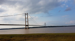
Up the Humber and Over the Bridge

The next morning, I rode through Grimsby and then onto the Humber to bridge that crosses the river west of Hull.

It is a very impressive suspension bridge.  Check out the Flickr photographs.

By-passing Hull

I had wanted to stay in Hull however there was no accommodation to be had. Hull is the European Centre of Culture for 2017.  As a result, accommodation has been fully booked for most of the year.

It was late in the afternoon as I pushed on along Route 1 towards the tourist town of Beverley.

I had already booked a campsite on farm close to Beverley.  As I pitched my tent, one  my neighbours came over and asked if I wanted “something to eat and drink”?

I ended up having a meal a couple of beers with him and his family.  He turned out to be very interesting bloke.  He was an ex Special Forces Soldier.  One of his sporting hobbies now days is diving.  He dives all around the British Isles coast.  He told me that diving is very popular in the UK.  This somewhat surprised me.

The bloke and his wife also gave me some breakfast in the morning.  I then headed into Beverley.

Flickr

Skegsness

https://www.flickr.com/photos/twwilko_photos/albums/72157685944761453

Louth

https://flic.kr/s/aHsm4eXA9d

Garmin

Leaving Kings Lynn to Sutton Bridge

https://connect.garmin.com/modern/activity/1946937490

Through Boston to Skegsness

https://connect.garmin.com/modern/activity/1948855710

From Skegsness to near Louth

https://connect.garmin.com/modern/activity/1950654482

Through Louth to Waltham

https://connect.garmin.com/modern/activity/1953182155

Waltham to near Beverley

https://connect.garmin.com/modern/activity/1962011462


Up the East Coast Days 7 to 12

36781362845_53762f8fdb_m

Cromer and onto Kings Lynn

From Lowestoft, the route took me north west through Great Yarmouth.  I cannot recall anything particularly ‘great’ about Great Yarmouth.

I had booked a pitch at Comer Hall Camping which turned out to be very close to the town.  It was somewhat confusing to find a place as the camping ground is on a large farm that also is the site of a zoo.  This confused even Google Maps.

Anyway, I finally found the place and there was a note on the office door, telling me to “pitch up anywhere I like”.

After setting up my tent, I walked into town.  There were lots of people wondering about the town.  I ended up having a meal a ‘gourmet’  hamburger place.  I rarely eat hamburgers, but these ones were OK.

The Pier

The hamburger restaurant overlooked the Comer Pier, which is a major tourist attraction in the town.  I walked down to the pier and took a photograph of the sunset.  There were lots of other people taking photographs of sunset.  It was very spectacular.

Good Café

In the morning, I wandered back into town looking for a place for breakfast.  I happened upon a small café which turned out to be very good.  The owners worked in the café and were very interesting to talk to. The wife is an avid trekker and frequently travels to Nepal where she undertakes long walks in the Himalayas.  All of the tips that are collected in the café are given to charities in Nepal.

Travellers Causing Trouble

As I wandered around the town after breakfast I noticed that they were a lot of policemen also wandering around the town.  This seemed rather odd for such a small town.  I asked one of  the policeman why there were so many of them around.  He said, “haven’t you seen the news about the troubles here”?  I said I hadn’t.

The policeman went on to tell me about the trouble there had been with ‘travellers’ that had descended on the town a couple of days ago.  Apparently, a very large group of mainly Irish ‘travellers’ arrived in the town in campervans.  The main trouble they caused was in restaurants and pubs where they ordered food and drinks, and then left the premises without paying.  They also abused people in the street.

Apparently, all this ‘carry on’  got quite a bit of a coverage in the national press.

Walking Around the Town

Cromer is nice town with a nice little beach and some interesting shops.  It was very pleasant just wander around and checked things out.

Library in Church

I also spent some time in the local library which is housed in an old church.  It is good to see old church been put to good use.

Waking up to Growling and Snorting

On the morning of the second day in Cromer I awoke to the sound of very loud growing and snorting.  Obviously, it was one of the animals in the Zoo next door.  I think we have all found ourselves sleeping in close proximity something that growls and snorts at some time in our lives.

Concert

In the evening , I booked a ticket to the show that was playing in the theatre which is located the end of the pier.  The show was old time ‘variety show’ that I suspect you would have been seen in the theatre between the two World Wars.  It had bit of everything – singing, dancing, comedy, and juggling.  All of the performers seemed to be able to do at least two of these things.

Lots of Dog

Comer is another town where everyone seemed have at least one dog.  There were dogs everywhere.

One family, I came across had white schnauzers.  I am very familiar with schnauzers, having owned two miniature schnauzers myself.  They were grey, also known as ‘salt and pepper’. The owner of the white schnauzers said, “these guys are just salt”.  She also said that they are always the centre of attention, and “when people ignore them they get upset”.

Short Ride to Sheringham

Leaving Comer, I had a very short ride to Sheringham where I stayed in YHA.  I had a private room which turned out to be very good.

Wells-next-to-Sea

After Sheringham, the route took me along the coast towards the quaintly named, Wells-next-to-Sea.

A couple of kilometres before the town, I saw the sign saying, ‘Miniature Railway’.  I followed the sign to check it out.

The railway turned out to be very miniature.  You can see a video of the train on Flickr.

The town of Wells next Sea was absolutely packed with tourists.  I only stopped briefly before heading towards King’s Lynn.  The route took me away from the coast through some pleasant villages.

Old Rectory

I had booked into a B&B called the Old Rectory in King’s Lynn.  This place turned out to be really good.  The owner had sent me a SMS with instructions were to find the keys and which Carey’s face in which locks.  Included in his message was a recommendation for a meal.  He recommended the restaurant in the hotel next door.  I took his recommendation and was pleased I did the meal was excellent.

Flickr Links

Cromer

https://flic.kr/s/aHsm3mKXRC

King’s Lynn

https://flic.kr/s/aHsm3cVUgM

Garmin Links

Lowestoft

https://connect.garmin.com/modern/activity/1946937360

Cromer

https://connect.garmin.com/modern/activity/1946937391

Sheringham to King’s Lynn

https://connect.garmin.com/modern/activity/1946937465


Riding up the East Coast Days 4,5 and 6

36618667221_c09f65d35b_m

From Felixstowe to Lowestoft

The Orwell Hotel in Felixstowe turned out to be very good.  It was great value at only AUD 60 per night.

Leaving Felixstowe

I got a bit lost leaving Felixstowe and heading north.  I was looking for the ferry that crossed the Deben River.  You would think it would be easy to find. The Garmin found it difficult.

I finally found the ferry crossing and continued heading north.  The route took me through the Suffolk Coast and Heaths Area of Natural Beauty (AONB).  While it was quite pleasant riding on mainly flat country roads, there wasn’t too much natural beauty to be seen.  There were, however, a large number of pig farms.  Each sow, appeared to have been given a small hut to live in.  I guess that that is better than nothing, and more humane than ‘battery farming’.

Staying in YHA in Blaxhall

As was riding along a noticed a sign to a YHA.  It turned out be in a village called Blaxhall.  The village really only consists of the YHA and a pub.

I checked into the YHA and headed to the pub for a meal.  As I was ordering my meal, the two lady cyclists that I had run into on the Felixstowe Harbour and Beach ferry, turned up in the pub.  We ended up having a meal together.  They were staying in, what I took to be, a very up market B&B not far from the village.

The YHA turned out to be very good. The YHA hostels in the UK have certainly changed a lot since I first stayed in them in the late 1970’s.  Those days, you are required to bring your own sheets,  and do chores such as sweeping the floors and cleaning the toilets.

There is none of that nowadays – staff in the hostel do all of that stuff. Also, most hostels like this one, serve alcohol and provide breakfast.

Into Adleburgh

Leaving Blaxhall, I headed towards the coast to the seaside town called Aldeburgh.  It is one of the more popular seaside towns that is in this part of the world.  It is known for its festival.  The festival had taken place the day before my arrival.  However, there were still lots of people in the town and there was no accommodation to be had for love or money.

I headed inland looking for a place to stay.

Camping in Lieston

I ended up staying in a campsite on farm just outside a village called Lieston. The contrast between this village and Aldleburgh was stark.  It is really amazing how villages that are so close together can be so different.

The only place to get an evening meal in Lieston was a very dodgy Indian restaurant.  I didn’t have a very good night’s sleep as a result of eating in that restaurant.

There was no place in the village that served breakfast.  A passing local told me that there was a reasonable café at Sizewell about five kilometres away. Sizewell is famous, or possibly infamous, for being site of one of the UK’s nuclear-powered electricity generating plants.

The café was on the beach and was very popular.  The power plant overlooks the beach.  I was really surprised at how many people were at the café.

Ride to Walberswick

After breakfast, I headed north on country lanes to a village called Walberswick.  It was a glorious English summer’s day.  When I arrived in Walberswick, there were people everywhere.  There were  almost as many dogs as people.  It seemed that there was a rule that said ‘you need a dog in your family to be allowed in the town’.

Row boat ferry to Southwold

Walberswick is on the southern side on the River Byth.  There are a number of ways to cross a river including Bailey Bridge over which the cycle path crosses.  However, there is also a small ferry.  This one turned out to be very interesting in that it was a rowing boat.  Check out the Flickr link to see a video of the ferry.

Lunch in Lord Nelson

After the ferry crossing I headed into Southwold for lunch in the Lord Nelson pub.  At some time in the future I will have to add up the number of Lord Nelson pubs that I have visited over the years.  I am sure it will prove to be a lot.  They can be found, not only in England, but around the world including Geneva.

On to Lowestoft and Trouble with Westpac

I headed onto Lowestoft, where I had booked a hotel on the beach front.

The ‘check in’ did not go well.  The receptionist told me that my AMEX card had been rejected.  I tried to use my Mastercard that is linked to the same account.  It was also rejected.  I called the Westpac so called ‘helpdesk’.

Westpac told me that both transactions where charged my account.  As we chatted I logged into the Westpac online app.  I could not see the transactions.  Indeed, the only transactions that I could see were from five days ago.

The hotel said that they needed proof that the transactions had been processed because, their  system had no record of them being processed.  That seemed a reasonable to me.  I asked the Westpac ‘helpdesk’ why I couldn’t see the latest transactions on my account. They told me that they were having problems with their systems.  This is something that Westpac customers have to put up with on a regular basis.

I had thought that things were getting better at Westpac , but it would appear that are not.  The problem is, as we all know, that it is difficult to change banks.  Also, there is no guarantee that the service will be any better if you do.

In the end, I had to pay for the room using my currency card. It was all very embarrassing.  I suggest to everyone, think twice about banking with Westpac.

Walk and Meal

Once I had finally settled into the hotel, I decided to walk along the seafront to find a place to eat.  I found a gastro pub which served a very good night baked seabass.  A bonus was that they accepted my credit card.

It was a bit cool as I walked back to the hotel.  Clearly, the end of summer was on its way.

Flickr Link

https://flic.kr/s/aHsm3khEHU

Garmin Links

Felixstowe

https://connect.garmin.com/modern/activity/1935320278

Blaxhall

https://connect.garmin.com/modern/activity/1935320300

Leiston

https://connect.garmin.com/modern/activity/1935320319

Up the East Coast Days 2 and 3

36648855486_d16e33f3f4_m(1)

To near Colchester and onto Harwick and Felistowe

It took me awhile to get out of Burnham on Crouch.  In fact,  it wasn’t until after lunch time that I finally left the town.

Past the Aerodrome

The route took me past an aerodrome.  There were a number of light planes flying around. One appeared to be a WWII Hurricane.

Getting at bit

In this part of the world, the signage on the Sustrans routes is a bit problematic.  I found myself getting lost a number of times.

Finding the Campsite

I had booked myself in to a campsite about five kilometres from Colchester.

It was late by the time I arrived at the site and decided to find a meal before pitching the tent.

Meal at the Alma Pub

A couple on the site suggested that I eat at the Alma pub.  While I was eating my meal, I noticed that there was cricket on the television.  It turned out to be the first Test between England and the West Indies.  What was really notable about this game was that it was the first Day/Night Test  to be played in England.

Unfortunately for cricket, virtually nobody in the pub seemed the slightest bit interested.

It was very late by the time I got back to the campsite. It was a bit of a pain, pitching the tent in the dark.

Chat with Norwich Couple

In the morning, I ended up having a rather a long chat, with a couple who were camped nearby.  They had only come from Norwich to told me that they often just head out into the country for short breaks in summer.

The bloke from told that owned a  Norton Commando 850 Mark 2 Interstate, that he was currently restoring.

Into Colchester

In the morning,  headed the short distance into Colchester where I had breakfast.  The major attraction of the town it is castle which dates back to Roman Times.

Onto Harwick

After leaving Colchester, I headed onto towards Harwich.

About 15 kilometers short of Harwick, I stopped briefly in a pub.

The notable feature of the pub was that they had a copy of the front page of the Sydney Morning Herald the day after England’s Rugby World Cup win in 2003.  The page was signed by Martin Johnson.

The landlord and great pleasure in showing me this memorabilia.

I was not impressed.

Ferry across to Felixstowe

I rode on to Felixstowe and  found the jetty for the ferry that would take me to the northern side of the harbour.  The ferry is known as the harbour and beach ferry.

On board I met two other cyclists.  They were  a couple of Englishwomen who were riding up the coast to Comer.

The ferry took about 15 minutes to cross the harbour, where we were to find how it got the second half of its name – we landed on a stony beach.

It was actually quite an effort to get the bikes over the beach onto firm ground.  It was then a short ride to my hotel, the Orwell in Felixstowe.

Flickr Link

https://flic.kr/s/aHsm1xAkPs

Garmin Links 

https://connect.garmin.com/modern/activity/1928778286

https://connect.garmin.com/modern/activity/1928778373


Up the East Coast Day 1

36605293916_eda60216b1_m

Southend on Sea

I rode from SW18 to Fenchurch Station in the City and caught the train to South end on Sea.

Faded Glory

I had book a night in the Bay Guesthouse that is on the Esplanade.  It is one of many such places in Southend.

Southend is one of many English seaside towns that have struggled since the 1970’s when the poms started travelling to Europe and beyond for their holidays.

There are lots of the ‘entertainment’ arcades and large ‘adventure’ park with mechanical rides.

Dinner on the Beach

I had a reasonable meal at a café on the beach.

The Pier

The main feature of the town is the pier.  It is the longest entertain pier in the world.  The reason for its length is the extraordinary tidal movements.

There is a train that runs along the pier.  A ‘ride and walk’ ticket is only GDP 2.50 for ‘Seniors’, including holders of NSW Senior’s Cards.  Very good value post Brexit Vote.

Ride to Burnham on Crouch

In the afternoon, I head towards Colchester.  This involved crossing the River Crouch on a very small ferry.

As I crossed the river, the heavens opened. I decided to stop in the town on the other side Burnham on Crouch. The ferryman suggested the White Harte Hotel. It turned out to be a good choice.


Flickr Link

https://flic.kr/s/aHsm2WTbH3

Garmin Link

To Fenchurch Train Station

https://connect.garmin.com/modern/activity/1925204848

North from Southend on Sea.

https://connect.garmin.com/modern/activity/1925204903


About Southend on Sea Pier

https://en.wikipedia.org/wiki/Southend_Pier

London August 2017

35821569923_9ec2306450_m

I travelled from Jersey via Portsmouth to London.

I arrived in time to join my hosts celebrate an ‘elderly’ neighbor’s birthday at a restaurant by the Thames. N.B. anyone born before 1955 is elderly in my eye’s.

My host’s left London for a few days to visit their granddaughters .  They were kind to offer me the use of the house. There was a condition however: “don’t set off the fire alarm”.

Pink Floyd Exhibition

I went to see the Pink Floyd exhibition at the Victoria and Albert Museum in South Kensington.

On the way there, I made my obligatory visit to the Zetland Arms.

The Pink Floyd Exhibition was great.  It has exhibits on each phase of their history, and related albums.  There is lots of memorabilia, including instruments and hand written lyrics.  There are also interviews with the band and other people.  The audio system works really well.

Motown Musical

I also went to the Motown Musical.  It about the history of the Motown recording label.  It uses hits from the era including songs by Diana Ross and the Supremes, The Jackson Five, Stevie Wonder and Smokey Robinson.

It is really good.

New Saddle

When I was in France, the tension bolt on my Brooks saddle fell off.  It is not possible to replaced the bolt without the assistance of a special machine that stretches the leather. This can only be done at the factory.  It was told by Brooks that this could take over a month.

Albeit that I could still ride on the saddle, I decided to lash out of new touring saddle. The old saddle will be installed on a ‘road’ bike in the future.

Off to South end on Sea

My next ride is up the East Coast of England.  I had decided to start from South end on Sea in Essex.

I road from SW18 to Fenchurch Station in the City and caught the train to South end on Sea.

Flickr Links

London

https://flic.kr/s/aHsm6FMczf

Pink Floyd Exhibition

https://flic.kr/s/aHsm2Fwocs

Pink Floyd Exhibition Link

http://pinkfloydexhibition.com/

Questions to Ask Climate Change Deniers and Skeptics and Related Views and Comments

Hurricane_Irma_wikipedia2

Is Carbon Dioxide (CO2) a Greenhouse Gas?

The correct answer is yes.

“Greenhouse gases most closely connected to global warming include carbon dioxide, methane, nitrous oxide and the fluorocarbons.

The greenhouse effect is caused by these gases in Earth’s atmosphere. Incoming solar energy passes through the atmosphere, which retains the resulting heat and warms Earth’s near-surface temperature. This effect is driven by the greenhouse gases, which capture and retain heat.

Consequently, the energy entering the atmosphere is greater than that leaving it, and this gradually raises the overall global temperature” (Sciencing, n.d.).

“The existence of the greenhouse effect was first identified 1824.  However, the term “greenhouse” was first used in this way by the Swedish Physicist Nils Gustaf Ekholm in 1901 (Wikipedia , n.d.).

What are Fossil Fuels?

Even the dumbest ‘denier/skeptic’ will get this correct.

“In common dialogue, the term fossil fuel also includes hydrocarbon-containing natural resources that are not derived from animal or plant sources.

Fossil fuel is a general term for buried combustible geologic deposits of organic materials, formed from decayed plants and animals that have been converted to crude oil, coal, natural gas, or heavy oils by exposure to heat and pressure in the earth’s crust over hundreds of millions of years”. (ScienceDaily, n.d.)

Does Burning Fossil Fuels Generate CO2?

The correct answer is yes.

“There are both natural and human sources of carbon dioxide emissions.

Natural sources include decomposition, ocean release and respiration.

Other…sources come from activities like cement production, deforestation as well as the burning of fossil fuels like coal, oil and natural gas”. (whatsyourimpact?, n.d.)

Does Human Activity Cause the Generation of CO2?

The Correct answer is yes.

Humans burn coal, gas and oil products.

The ‘denier/skeptic’ will almost certainly drive a petrol or diesel powered car.

Does Nature Absorb CO2?

The correct answer is yes.

“Plants absorb carbon dioxide from the air, combine it with water and light, and make carbohydrates — the process known as photosynthesis” (theconversation, n.d.).

The ‘denier/skeptic’ will often tell you this simple fact in a tone of voice that suggests that you have never heard of photosynthesis.

Other ways nature absorbs CO2 is includes absorption by the oceans.

For many years scientists have known that about 40%   of the carbon dioxide generated by human activity gets absorbed in the ocean waters”. (The Guardian, n.d.)

There is a possible issue with this however:

“When carbon dioxide (CO2) is absorbed by seawater, chemical reactions occur that reduce seawater pH, carbonate ion concentration, and saturation states of biologically important calcium carbonate minerals. These chemical reactions are termed “ocean acidification” or “OA” for short” (pmelcarbonprogram, n.d.).

Ocean acidification “expected to impact ocean species to varying degrees” (pmelcarbonprogram, n.d.).  It is thought to be a reason for the bleaching of coral reefs including the Great Barrier Reef.

Are levels of CO2 in the Atmosphere Increasing?

The correct answer is yes.

“Ancient air bubbles trapped in ice enable us to step back in time and see what Earth’s atmosphere, and climate, were like in the distant past. They tell us that levels of carbon dioxide (CO2) in the atmosphere are higher than they have been at any time in the past 400,000 years”. (NASA, n.d.)

More importantly, on May 9, 2013, the daily mean concentration of carbon dioxide in the atmosphere of Mauna Loa, Hawaii, surpassed 400 parts per million (ppm) for the first time since measurements began in 1958 (NOAA Research, n.d.).

Is the Increase in CO2 in the Atmosphere Related to the Burning of Fossil Fuels?

It would appear that it is:

“Before the Industrial Revolution in the 19th century, global average CO2 was about 280 ppm. During the last 800,000 years, CO2 fluctuated between about 180 ppm during ice ages and 280 ppm during interglacial warm periods.

Today’s rate of increase is more than 100 times faster than the increase that occurred when the last ice age ended” (NOAA Research, n.d.).

Has the Climate fluctuated in the Past?

This is a favourite line of the ‘denier/skeptic’.  They will tell you the climate has always been changing.  They often tell that in tone that suggests that they are aware of that fact and you obviously aren’t.

The answer is yes, the climate has always been changing – there have been periods of ‘ice ages’ and more temperate periods.

This fact is known to everyone of the planet, with even a modest level of education.

For example, this from a UK Infants School curriculum:

“Stone Age to Iron Age covers around 10,000 years, between the last Ice Age and the coming of the Romans. Such a long period is difficult for children to imagine, but putting the children into a living time-line across the classroom might help” (Historical Association , n.d.).

What is the Probability that Scientists are Unaware of Past Climate Fluctuations?

Let’s get real, the answer is nil.

The scientists are almost certainly to have IQs more than 15% higher than the average person.  They will likely to have post graduate degrees, including doctorates. They will all have been to Infants School or its equivalent.

Who thinks that Anthropocentric Climate Change is Real?

As we all know, it is widely reported that 97% or more ‘Climate Scientists’ believe that human activity is changing the world’s climate.

NASA reports the following:

“Multiple studies published in peer-reviewed scientific journals1 show that 97 percent or more of actively publishing climate scientists agree: Climate-warming trends over the past century are extremely likely due to human activities.

 In addition, most of the leading scientific organizations worldwide have issued public statements endorsing this position”. (NASA, n.d.).

The ‘Paris Agreement’ suggests that all of the world’s leaders with the exception of Donald Trump and President Assad of Syria believe that Anthropomorphic Climate Change is real (UN Framework on Climate Change , n.d.).

Who doesn’t think that Anthropocentric Change is Real?  

We all know a few: Donald Trump, Pauline Hanson, and so on.

You maybe one yourself.

You maybe married to one.


Manchester Bay to San Francisco

New Phototastic Collage

I was pleased to be leaving Manchester Beach.  As I continued along the coast, the fog slowly lifted and the temperature rose.

The road got narrower and the short sharp ascents and descents became more frequent.

Ocean Cove

It was late in the afternoon when I arrived in a small place called Ocean Cove.  There wasn’t much to it, but it had all that I need: a Bar and Grill, a small store and a camping ground.

The Bar and Grill had  great views across the cove to the ocean. The food was good and the craft beer, was excellent as always.  There were some binoculars on the bar, for the purpose of looking at passing whales.

In the morning, I returned to the Bar and Grill for breakfast.  Unfortunate this was very ordinary.

Climbing over Jenner Hill

Next day, I headed to Bodega Bay.  This involved climbing over Jenner Hill.  It was quite a climb. The road was also very close to the cliffs that drop directly into the ocean below.  Check out the Flickr photos and video.

The road was very busy, will the tail end of the Memorial Bay traffic heading south.

There were also lots of land slips. They had caused one lane to be closed with traffic lights stopping the movement of the vehicles in one direction at a time. I was able ride to the front of the line of cars and RVs at each land slip.

I noticed one particular vehicle, an old VW Combie. It would pass me and then come to a stop at a land slip.  I would pass it as I went to the front of the line. When lights changed, I would head off and was passed by the cars and RVs, including the VW.  At the next land slip, the above would be repeated.  It was the classic ‘tortoise and hare’ thing.

Stopping for Lunch

Near Jenner I stopped for lunch in the very flash restaurant that looked across the beach to the ocean.  The food was excellent, if somewhat expensive.  The bartender told me that this part of the coast was “a well-kept secret until recently.  It has been discovered by the IT crowd in the Bay Area”.

On to Bogeda Bay

I continued onto Bodega Bay.  The only accommodation on offer were motels and guest house.  I was lucky to find a vacancy in the Bodega Bay Inn. It was Ok, but turned out to the most expensive accommodation on my trip so far.

The Inn, however did offer a reasonably good ‘continental’ breakfast with muesli and fruit.  Such fare is not usually on offer in my experience of USA motels.

The One Takes a Turn

After Bodega Highway One heads East inland and towards Highway 101.  At Forde Valley, it heads back towards the coast.  Most of the traffic heads towards the 101.

I continued on ‘The One’. It was somewhat surreal to be travelling on the road with virtually no traffic.

I stopped in a tiny place call Tomales for lunch, a basic cheese and tomato sandwich.

At a place called Inverness, I noticed a lot of cars parked by the road.  The attraction turned out to be an oyster farm.  They were serving fresh Pacific Oysters and cold beer.

I sat bench eating oysters and drinking craft beer.  I got into conversation with a couple with a huge Afghan Hound. Check out his photo.

I headed onto Point Reynes where I stopped for a meal.

After yet another very good meal and a couple of good craft beers, I headed on to Olema where I checked into a RV and camping ground.

In the morning, I headed inland towards Fairfax on the Sir Francis Drake Boulevard which passes through the Samuel P Taylor State Park.

As I rode into Fairfax, the traffic became very heavy.  I heard someone called out “are you lost”? It turned out to be a fellow cyclist.  He rode over to me and asked, “where are you headed”? I told him that I was headed to San Francisco.  He said “you need to stay off this road and offered to show the way on bike route.

This turned out to be very good.  However, it was a good job that he led the way as the route was not very well signposted.  There were some parts on paths and other parts on back streets.  The bloke was on an electric bike.  He had converted it himself.  It had motors in both the front wheel and the crank.  It was seriously quick.

The bloke led me as far as Mill Valley, close to where bike path meets the 101.  There was one last steep climb before the path dropped down into Sausalito on San Francisco Bay.

Sausalito

I stopped for lunch in fish restaurant on the bay.  It was really good.

 Golden Gate Bridge

After lunch, I continued onto the Golden Gate bridge.

For some reason, the west side of the bridge is closed to cyclists after 3.00 p.m.  A guard of the bridge told me that I could cross to the other side and ride there.  Crossing to other side meant walking the bike down and up ramps next to a long flight of steps.  There was no way that the bike could fit on the ramp with the panniers onboard.  I decided to walk.

Half way across the bridge, I walked into a bank of fog.  It was somewhat surreal.  To the east the sky was clear and sunny.  To the west, the bridge was covered in thick fog.

Riding into Down Town San Francisco

Once over the bridge, I hopped on the bike and rode along the bay towards  Fisherman’s Wharf and the onto my hostel, in Mason Street, one block from Union Square.

Flickr Links

From Manchester Beach into San Francisco

https://flic.kr/s/aHskYrS9XW

Garmin Links

Manchester Beach

https://connect.garmin.com/modern/activity/1768265268

Jenner

https://connect.garmin.com/modern/activity/1768265324

Bogeda Bay

https://connect.garmin.com/modern/activity/1771070204

Point Reyes

https://connect.garmin.com/modern/activity/1771070240

San Francisco

https://connect.garmin.com/modern/activity/1792798469

Benbow to Manchester Beach

I left Benbow around noon.  The route took me directly south on the 101 and towards Leggett.  It was very hot and some of the hills were very steep.

The road followed a river which cut through pine forests.  A feature of the road was some spectacular bridges over the river.

Standish Hickey State Park

The guidebook that I was vaguely following recommended the Standish State Park as a place to stay.  The state Parks are typically very good, however, they are often a long way from towns and places where you can buy food.  This is a problem for me as I do not have space to carry food on the bike and I don’t have any cooking equipment.

This particular park was okay as it was opposite a shop which also sold cooked meals and cold beer.

I  checked into the camping ground and after I pitched my tent and headed across to the store for a meal.

While I was eating a meal, I got into conversation with an older couple from Oregon who were riding an Indian motorcycle similar to a Harley Davidson.  They said that they bought the Indian just because they “didn’t want to be the same as the Harley riders”.

Leggett Hill

Next morning, I headed into the small town of Leggett, where the 101 joins the Highway One, known locally as ‘The One’. This highway heads to the coast and follows it all the way south to San Francisco.

Leaving the town, the highway climbs steeply up the Leggett Hill. This one of the major climbs on the Pacific cycle route.  It is a long and steady climb.  Nearing the top, I saw a fellow cyclist coming the other way. We stopped for a chat.  The other cyclist turned out to be a French women.  She told me that she had ridden from San Francisco when she was struggling as she was “getting over an operation”.  This had meant that she was forced to walk up any steep hills.  On this day, she had “walked over 15 kilometers”.

The run down from the top of the hill to the coast was a great decent.  Check out the GoPro on Flickr.

As I got closer to the coast, the temperature dropped dramatically from over 30 degrees centigrade to less than 15 degrees.  The cause of this dramatic drop in temperature was a thick fog rolling in from the ocean.

Westport

I headed south along the coast until I came to a very small town called Westport, where I checked into an RV Park and camping ground.  It was a very pleasant camping ground close to a river.

The wasn’t much to Westport, apart from the park and small store which sold take-way food and beer.

Continuing along the Coast

Next morning, I continued along the coast south towards Ft Bragg.  This part of the coast, is also very spectacular, albeit the sky was dull due to the fog.

In Fort Bragg, I stopped briefly at a bike shop to pump up my tyres.  The owner of the bike shop told me that business was good.  This was pleasing, if somewhat surprising, to hear given that there didn’t seem to be many local cyclists on the road.

Fort Bragg

I had booked a motel online.  It turned out to be quite a long way from the centre of town.  Ft Bragg, like many towns that I encountered on the route, is strung out along the highway which passes through it.

After checking into the motel, I walked back into the ‘centre’ of the town to have a meal in the local brewery.  It was a reasonable meal and a beer was excellent.

Leaving Fort Bragg

After leaving Ft Bragg, the road narrows considerably, as it hugs the coast.  There are a long series of very steep climbs and descents, as the road leads down into the onto beaches, followed by sharp climbs to ridges above.

Manchester Beach

It was late in the afternoon, when I arrived in Manchester Beach.  The only place to stay was an RV camping ground.  This was also the first day of the Memorial Day weekend.  This meant that the camping ground and all other accommodation along the coast to San Francisco was close or full to capacity.

I was able to get a pitch for my small tent, however, I had to pay the full price, of USD 40 for it.

I am sure that Manchester Beach, can be a nice place, however this week it was very gloomy with a constant high-level fog, which also kept the temperature very low.  Notwithstanding, the gloomy weather, I decided to stay in Manchester Beach two nights.  This was primarily due to risk of not being able to find any accommodation further south.

As it turned out, I had number of interesting conversations with people staying in the park.  They seemed to be enjoying themselves despite the weather. As is one couple explained to me, Memorial Day “marks the beginning of the summer season and end of the winter and it had been a long and wet winter”.

Flickr Link

Benbow to Fort Bragg

https://flic.kr/s/aHskVKtesU

Garmin Links

Benbow

https://connect.garmin.com/modern/activity/1758819097

Leggett

https://connect.garmin.com/modern/activity/1758819137

Westport

https://connect.garmin.com/modern/activity/1758819160

Fort Bragg

https://connect.garmin.com/modern/activity/1762336138


Coos Bay to Benbow

Benbow

I stayed in a Motel 6 in Coos Bay.  They are simple, but very clean and relatively inexpensive despite the soft AUDvUSD,

Walk to Brewery

It was a short walk from the Motel to the local Brewery, which as it turned out, was that only place in town that was serving food on Sunday.

The beer was good and they served a reasonable salmon meal.

Bus to Brookings

I ended up deciding to take a bus from Coos Bay to Brookings.  This wasn’t a particularly good stretch of the route to ride. There were some parts of the coast that were spectacular, but this was interspersed with some very boring bits.

Brookings was Damp

After getting off the bus, I took a short ride to the Brooking Harbour where I checked into a RV Park.

These are interesting places. I came across them in my last trip to California three years ago.  Typically, they are a few kilometers out of the major towns, or in very small towns or villages. Most of the RVs are huge, sometimes as large as buses.  Often they tow cars.  This is needed as the owners have to drive relatively long distances to shops and other services. Sometimes they use motorcycles and even more rarely, they use bicycles.

I pitched my tent at the far end of the park.

Another person worried about Trump

I then headed to a nearby restaurant where I had a reasonable meal. At the bar I got into a conversation with a bloke who told me that he was a ‘trader’. He had been a ‘day trader’, but the “algorithms had killed that”.  He told me that he now trades over a longer horizon, weeks or months.

As is often the case, the conversation, drifted into politics and Trump.   He said that he had “gone short on the USA”.  This included the USD, stocks and property in the expectation that Trump will “implode and take the country with him.

As I walked back to the tent, it started to rain. It poured down all night.

In the morning, it was still pouring with rain.

I headed back the restaurant for breakfast.  This turned into lunch, as the rain continued to fall.

There was a brief period when the rain stopped. I took a short walk to a coffee shop.  It had decent coffee, a rare commodity over here.

I ended up having another meal in the restaurant, before an early night in the still very damp tent.

Riding to Crescent City

In the morning, I stopped briefly at the coffee shop, before heading off down Highway 101 towards Crescent City.

The road run parallel to the coast and near to the very large sand dunes that are a feature of this area.  There are lots of places where you can rent ‘All Terrain Vehicles’ ATV’s to ride on the dunes.  There are also a lot of SUV’s carrying ATV’s.  They  appear to be a land version of Jet Skis and appeal to the same type of person.

Crescent City

I rode into Crescent City and found it to be a like a lot of towns that I have encountered in my visits to the USA: it has no discernable centre.  This is a strange phenomenon. It seems to be the result of a number of factors.

These include: that fact that the original buildings were not very substantial and when the highways came along, the focus of the towns moved to the highway. When this occurred, the original centres of the towns were demolished and replaced with other building.

Unlike English and European towns and villages, there is no town square which forms that centre of the place.  In Australia, there is usually a park and the Post Office, major banks and hotels that form the centre of small towns.  In the USA, there are usually just a ribbon on buildings along the Main Street, will no actual ‘centre’.

I stopped at the Information Centre and asked for some advice about accommodation and food. They told me that there was an RV Park that allowed camping and there was a good Brewery that served “excellent food”.  Those were my only needs.  I decided to stay.

It was blowing a gale when I pitched my tent.  Check out the video of Flickr.

Brewery

The Brewery turned out to have very tasty beer and food.  The staff very friendly.

Over the Hill

Next morning, I struggled to find a place to have breakfast.  It seems that cafés in small town USA don’t do anything other than cooked breakfasts that involve eggs and bacon or pancakes. I had to settle on the latter.

With a load of carbs, I headed out of town and up the Crescent Hill.  It was quite a climb.

The descent down the other side of the hill brought me close to the ocean.  It is very spectacular.  Check out the videos.

Unfortunately,  the ride was spoilt by a ‘bogan’ in an oversized  SUV. Check out the Flickr video.

The next part of the ride was quite pleasant, passing some lakes and the start of the Redwood forests.

For brief stretch, the cycle route left the 101 and passed through some small village including Smith River. The road was flat and I had a tail wind.

Klamath

I arrived in a small town called Klamath in the late afternoon.  I went to the Information Centre and was told that there was RV Park that allowed tents just out of town.

The park turned out to be really good.

Klamath  is a ‘Tribal Town’.  This means that it is primarily populated by native Americans and they own much of the land.  They also have special rights to operate Casinos in towns such as these.

Bus to Fortuna

The owner of the RV suggested that I take a bus for the next bit of my journey South.

The bus left in the mid-afternoon.

It stopped in Eureka where I caught a local bus on to Fortuna.

Fortuna

I had booked into a motel using Booking.com.  It was a shocker, run by an Indian Basil Faulty.  I hope my review on the site does what I hope it does.

Into the Humboldt State Forest

I took a short local bus ride from Fortuna to Scotia.  This was all on the Freeway and no good for riding.

From Scotia, it was a short ride along the 101 before I turned off onto the Avenue of the Giants that takes you through the Humbolt State Forest.  This famous for its Redwood pines.

Check out the Flickr photos.

Meyers Flat

I stopped in a small village called Meyers Flat.

Surprisingly, it is really run down.  The only restaurant in the place has closed down.  There is a B&B that  is very expensive.  Apart from that, there is a Saloon and a ‘Market’, with limited supplies.

There is however, a RV park near the river about 200 metre from the village.

I checked in and pitched my tent.

I then walked up to the Market where I bought a hot dog and a sandwich.  I then headed to the Saloon.

It was like something out of the ‘wild west’.  The owner, in his 80’s was sitting in a lounge chair holding a revolver. The Barmaid, called Olive told me that she was from London and was living nearby with her boyfriend. A ‘local’ sitting at the bar told me that “this is weed country” and that “most of the people here grow the stuff or are here to smoke it because it’s cheap”.

RV Park was very secure.  The owners said that “this was necessary due to a lot of petty theft by the locals.

Leaving the State Park

It was a short ride along the Avenue of the Giants when I was back on the 101 and into Garberville.  I had been told by the owners of the RV Park in Meyers Plain that this was a “bad town” and I should head on to Benbow.

Dodgy Town

As I rode through Garberville, I couldn’t see any signs for Benbow.  I saw a couple of policemen and stopped. I said “I need some advice”.  One of them said “don’t hang around here” and laughed.  I said “am looking to go to Benbow” and he replied “good idea” .  He told me that all I had to do was stay on the 101 and head over the hill.

I asked him “what was wrong with the town” ?.  He replied, “homeless people on drugs. They stay here because they re close to the shops”.

Benbow

I headed over the hill to Benbow.  It turned out to be a good place.  It has a RV Park with a golf course and the Benbow Inn.

I checked into the RV Park and pitched my tent before heading over to the Inn for a meal.

The Inn is a mock Tudor Hotel that was built in the 1920’s.  I was a popular with the early Hollywood stars.  It would appear to have had mixed success since then, but is being extended.  I guess is looking to a new lease of life.

In the morning I awoke to the sound of two blokes speaking Dutch.

They turned out to be fellow cyclists.  They are riding from San Francisco to Calgary.  I told them that they may strike some strong headwinds and that I experienced that when I rode from LA to San Francisco three years ago.  They said had already experienced that.

Both their bike had Rholoff gears and carbon chains.  They said that the chains are really good.

I will have to look into getting one.

I decided to stay in Benbow for the day.  It was really hot.


Flickr Links

Brookings to Crescent City

https://flic.kr/s/aHskVDdmqr

Crescent City to Klamath

https://flic.kr/s/aHskVDeGKT

Klamath to Fortuna

https://flic.kr/s/aHskXi7Sg1

Avenue of the Giants and Benbow

https://flic.kr/s/aHskVsqAch

Garmin Links

Brookings

https://connect.garmin.com/modern/activity/1741521028

Crescent City

https://connect.garmin.com/modern/activity/1741521126

Scotia and Meyers Flat

https://connect.garmin.com/modern/activity/1747678621

https://connect.garmin.com/modern/activity/1747678642