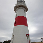
Coles Bay to Launceston

Low Bay Lighthouse

Coles Bay to Launceston

I headed up the coast from Coles Bay.

Bicheno

I stopped in  Bicheno.  This a bit of a sorry place.

It is one of the Tasmanian towns that has signs up saying “Free Wi Fi”.  I decided to definitely find the service in this town as I had not been able to find such services in other towns.  As it turns out the WiFi ‘Hot Spot’ in Bichino is an open space opposite the shops.  There is no place to sit.  In the middle of the day, unless you are in a car, you can’t see your computer screen very well because of the glare.  Also, you can’t download or upload files using the service.  All it is good for is reading emails and simple web sites.  It is free and close to useless.

Iron House Brewery

I was pleased to leave Bicheno and continued north.  I had brief stop at Iron House Brewery.  This part of the Whites Sands Resort – example of a ‘high end’ tourist development.

http://www.white-sands.com.au/

St Helens

I continued on to St Helens and checked into the local Backpackers.  It was packed.  There were a group of cyclists on an organised tour.  One of the recognised me – he still works for the Dept of Finance and Services.

The owner of the hostel was keen to chat.  He told me that he had been in the town for over ten years, but was still seen as an outsider.  He confirmed the issue of which  I had become acutely aware – the dual nature of tourism and other industries  in Tasmania.  There are those that want to move head providing high value, high margin products and services such as quality wine and cheese, craft beers etc. and ‘eco’ experiences.  On the over side there a lot of Tasmanians that want to return to 196o’s and see only way a head is to cut down trees and dig up mineral.  These people don’t want tourists in their state.

One very telling point the bloke made was that he had given up on employing locals. He said that “anyone with any brains  had left the place”.  Those that were left simply did not have ability to perform task he required e.g. operate a computer, handle money and speak with his quests.  He only employs itinerant backpackers, preferably from Europe.

Bay of fires and Over the Hill to Weldborough

In the morning I took a brief detour to the Bay of Fires.  The sand is white, the water blue and rocks red.  All very nice, but I must say by this stage all the beaches had started to look the same.

I headed west towards Weldborough.

I took a back road which provides a bit of a short cut compared to the main road.  The country was beautiful, but the ride was rough – dirt and steep.

Ales and Triumphs

It was late when I finally made it into Weldborough.  This place essentially only consists of the pub and about 20 houses.

The owner of the pub has decided to specialise in craft beers.  The place has also become a favourite  stopover for ‘sophisticated’ bikers.  There was group of Truimph riders the night I was there.

I pitched my tent in the paddock behind that pub.  The showers were basic but clean

Bridport

The ride to Bridport the next was nothing to write about.

I stayed in the camping ground at the water’s edge.  Not a bad spot.

Awful ride to Georgetown

Next day I head to Georgetown which close to mouth of the Tamar River.

It turned out to be a horrible stretch of road, with lots of trucks travelling both directions a narrow, if any verge. Several times I was forced off the road.

I decided that when I got to Georgetown, I take the bus to Launceston.

Launceston

I ended up having to stay the night in Georgetown.  In the morning I rode out to Low Head before heading back to catch the bus.

Launceston

I took the opportunity to check out the Carraract Gorge the afternoon I arrive in Launceston.  I was a pity it was so smokey

The next day I flew to Canberra via Melbourne.


Flickr Link

https://flic.kr/s/aHsjUxQ6XK

Garmin Links

Coles Bay to Bicheno

http://connect.garmin.com/activity/458510351


Bicheno to St Helens

http://connect.garmin.com/activity/458510371

St Helens to Weldborough

http://connect.garmin.com/activity/458510390

Weldborough to Bridport

http://connect.garmin.com/activity/458510416

Bridport to Georgetown

http://connect.garmin.com/activity/458510433


Port Arthur to Coles Bay

Wineglass Bay

Port Arthur to Coles Bay Tasmania

I decided to take the bus south from Hobart to Port Arthur.  This because there is essentially only one road and I hate riding over the same roads twice.

I checked into the camping ground and headed off for a meal in a mock English Pub.  I had mu laptop set up on the table.  After the main course I left the restaurant to get a charger that I had left in the pannier on my bike.  One of the staff came running after me and said “you can’t leave without paying”.  I asked him to follow me back to my table.  My laptop and camera were on the table. I asked him did he “really think I was trying to leave without paying?”.  He simply walked off.

A father and daughter couple sitting next to me witnessed that above encounter.  They told me that they were locals.  They also said there is no limit what to expect in this part of the world.

Tasman Island

Next day I booked on a boat tour from Port Arthur to Pirates Beach via Tasman Island.

This was fantastic.  Check out the photos they tell it all.

Tour of Port Arthur

Of course being in Port Arthur I had to do a tour of the old prison.  That is a grim place place on two counts – the convict history and the massacre.

Just of the massacre, I must say that John Howard has to admired for standing up the gun lobby and strengthening gun control and  initiating the gun ‘buy back’.  It is a pity something similar can’t be done in the USA.

Ride to Dunnelly

After seeing Port Arthur, I took the short ride to Dunnelly.  That is a really small place.  The pub allows you to camp in the adjoining vacant block of land.  It is really basic with no facilties.

Tough ride from Dunalley to Triabunna

The ride north was tough.  I took the back road, which was mainly dirt.  I was quite wet and hard going.

Just before Triabunna, I stopped for a coffee in a café.  There was a GS 1200 BMW Adventure bike in the car park.

Tall Lady on BMW

After ordering my coffee I sat down near a couple who were obviously on the bike.  We had a chat about the bike and other things.  The woman was very attractive – much like Megan Gale.  Part way through the conversation she stood up and went out to the bike.

An older women sitting nearby commented: “your wife is very tall”.  The bloke responded: “yes she is 6’ 2” in old money and she is my second wife.  The first one was too short”.

The woman returned and they them both left to get on the bike.  He was a good 6”s taller than her.  When they got on the bike, they made it look like a Postman’s scouter.

Triabunna

I head up the coast to Triabunna and check into the caravan park.  I ended up sharing the ‘backpackers’ cabin with a fellow cyclist – a woman form Germany.

Day on Maria Island

The next day I joined the German Lady on a trip to Maria Island which is located about 20 klms to the east of Triabunna.

The island has an interest history.  At one stage it was settled by an Italian and his family. It tried to establish a wine growing business. It wasn’t successful.  The island is now a National Park.

Swansea

I continued up the coast stopping at Swansea, before heading across to Coles Bay.

Coles Bay

Coles Bay is famous for the Hazzards (rocky mountains) and Wineglass Bay.  The late is thought to one of the most picturesque beaches on the planet.  Check out the photos and you be the judge.

I stayed in the YHA in Coles Bay.  I will never forget the stay for two reasons.  The first was that early in the morning the place was flooded by a torrential downpour.  The water rush down the hill right through the hostel and down into the shops and tavern below.  It took hours for the staff to clear water with the assistance of local fishermen with bilge pumps.  The second reason was the presence of a young Argentine girl.  She can only be described as unnecessarily attractive.  Her and her husband want to stay in Australia.  He would have to be be one of the most privileged blokes on the planet.

Flickr Links

Tasman Island and Port Arthur

https://flic.kr/s/aHsjTXeY6A

Maria Island

https://flic.kr/s/aHsjSx7kfg

Coles Bay

https://flic.kr/s/aHsjSQnmv2

Garmin Links

Dunnalley to Triabunna

http://connect.garmin.com/activity/458510242

Maria Island

http://connect.garmin.com/activity/458510254

Triabuuna to Swansea

http://connect.garmin.com/activity/458510273

Swansea to Coles Bay

http://connect.garmin.com/activity/458510300

Wineglass Bay Walk

http://connect.garmin.com/activity/458510323


Hobart

MONA Hobart


Hobart

I stayed in Montgomery’s Hotel/Hostel in Hobart’s CBD.  It is close to Constitutional Dock and Salamanca Place.

Hobart is physically quite an attractive place.  Mt Wellington towers over the city and the river/harbour is quite spectacular.   The dock and Salamanca Place area have some interesting old buildings and cafes and bars.  The rest of the place is a bit naff to say the least.

Bruny Island

On the second day I decided to take a tour to Bruny Island which is to south of the city.  It is known for its beaches, lighthouse and food – including cheese, whiskey and seafood.  The tour was on a small mini-bus.  The others on the tour were all ‘mainlanders’ .  As always you end up chatting to others on such a tour.

A couple from Perth were particularly interesting.  He was a South African that been in Perth for over 20 years, working in the mining industry.  He had some interesting comment to make about the opposition to the Mining Tax.  In short he thinks that the absolution of the tax is the greatest rip-off of the Australian taxpayer.  He also thinks that the WA economy will be hugely impacted when the construction work related the latest mining boom comes to an end.  Apparently the lastest mines are so mechanized that they hardly need anyone to operate them.

The scenery on the island is pretty good.  Check out the photos.

MONA

The next day I took the ferry to the Museum of Old and New Art  (MONA).  This is a must see.  Check the URL and the link to piece about its founder and owner.

https://www.mona.net.au/

http://www.themonthly.com.au/issue/2010/december/1360112582/amanda-lohrey/high-priest

The best exhibit was a sculpture of the digestive system.  At the end there is pile of the what comes out of humans.  It smells appropriately.

Monday was Hobart Cup Day.  I spent the day in town, including a late lunch in Salamanca Place.  Apparently the races were called off due to storm.  A lot of the patrons ended up in the restaurants in Salamanca Place.

The next day a spent some time wandering around the inner city area including a visit to the Wrest Point Casino.  This was that first legal casino in Australia.  It is a seriously depressing place.

Old Hut and Old Ship

I also checked out the replica of Douglas Mawson’s Hut.  That is well worth a visit.

I also took the opportunity to board the HMAS Trobuk which was in town.  I last saw that ship when I was working for Foreign Affairs.  I was on a trip through the South Pacific in May 1986 when Cyclone Namu hit the Solomon Islands.  HMAS Trobuk was part of the Australian disaster relief effort.  It provided supplies and actually powered Honiara until the generators of the island could be restored.

http://en.wikipedia.org/wiki/Cyclone_Namu

Up and Down Mt Wellington

I could not be in Hobart and not ride up Mt Wellington.  I did that on my last day.  Check out the Garmin link and the photos.

Garmin Link

http://connect.garmin.com/activity/443700983

Flickr Link

https://flic.kr/s/aHsjRXdLtX

Tasmania – East to Hobart

To Queenstown

East to Hobart

I was pleased to leave Strahan.  This is a pity because I had high expectations of the place.

It is relatively short ride to Queenstown, albeit there is a bit of a climb. It was hot and the newly tarmac road did not make for a pleasant ride.

Queenstown

As you approach Queenstown you can see the devastation that the mining has caused. There are a number factors.  The first was the impact of the mine itself, with the resulting slag heaps.  The next issue was the felling of the trees within the vicinity.  The trees were cut down to provide fuel for the smelter that processed the ore.  The fumes of the smelter were toxic and killed most of the remaining vegetation and regrowth.  Finally, because the vegetation had disappeared, there was nothing to hold the soil and it was washed away by the torrential rainfall that is feature of the area.

The result of the above was a severely scarred landscape, of bare clay and rock.  Albeit, there has been some re-vegetation the landscape continues to be severely scared.

Once in town, I looked for the camping ground.  The route to the ground took me over the river.  It is a bright orange colour, and doubtless lifeless. What a mess. Checkout  the photos.

At the reception I asked if there grass where the tent area was, as  it appeared that the camping ground was all gravel.  I was assured that there was grass.  I made way along the path to the tent area.  There was a tiny sliver of grass along the fence.  A tent was pitched up against the tent and two bikes were nearby.

As I pitched my tent the owners of the bikes arrived.  They turned out to be a couple from Luzern in Switzerland.  They too were somewhat disappointed with the ‘grass’ or rather lack of it.  We had a quite a long chat about our experiences on the road.  They were shocked by the narrowness of the roads in Tasmania and the size of the trucks.  They told me that they thought it was “very dangerous” and would not recommend touring Tasmania by bicycle to any of their friends.

I headed into town for a meal at one of the pubs.  It wasn’t a bad meal.

Ride to Derwent  Bridge

As I rode out of Queenstown, the place looked more derelict than ever.

The road leads up the mountain above the town.  From the bottom it looks like a daunting ride.  Surprisingly, the gradient is not too bad as the road zig zigs around the contours of the ridges.

As I reached the top of mountain, the air became thick with smoke.  I had heard that a major fire had been through the country between Queenstown and Derwent Bridge.  It appeared that they were still going.

As I rode on, I was passed by lots of Harley Davidsons, obviously part of the HOG ride, I had come across in Strathan.  They are seriously noisy bikes.

The weather got hotter and hotter as I progressed.  How was it that on the two toughest climbing days of the trip, the temperature was over 35 degrees????  One saving grace was that there were plenty of opportunities to get water from the pristine streams that cross the road.

At one point I came across an area of bush that had recently been burnt by the bushfire.  The trees were still smoldering and the air was thick with acrid smoke.  Again, have a lot at the photos.

Derwent Bridge

It was quite late when I finally made it into Derwent Bridge.  There is very little in Derwent Bridge apart from a hotel.  This place has some really basic accommodation.   That was all I needed.

I ordered a meal and had a long one-sided conversation with the owner who complained about tourist numbers being down, the Tasmania Government, the Carbon Tax (he was unable to explain how that had an adverse impact on his business given his electricity was hydo-power) and a litany of other issues.

In the morning, I rode the 5 or so  klms to Lake St Clair.  It is another beautiful spot.

On the way back to Derwent Bridge I noticed a snake on the side of the road.  I had seen lots of dead snake on the trip so far.  They obviously like to warn themselves on the hot road surface.  Unfortunately for them, the drivers of cars and trucks are happy to run them over.

I though the snake on side road was probably dead given there was a lot of flies about.  I also thought I would make a good photo it appear to have been only recently killed and was not quashed.  I circled back to take a photo.  As I approached, it started to slither ahead of me.  I immediately turn around and peddled as fast as I could.  I was a Tiger Snake.  As many readers would know, if you get bitten by a Tiger snake, you can kiss your arse goodbye unless you are within minutes of getting antivenin.

It would be really good to do the Cradle Mountain to Lake St Clair walk.

Tarraleah

After Lake St Clair, I head on to Tarraleah.  Some friends who had travelled through Tasmania last February, put me on to this place.

It is an ex-hydroelectricity town that was built to house the construction workers.  When that dams were finished, it limped on for a awhile before, becoming derelict.  Someone bought the whole place but could not make a business of it.  They sold it to the current owner, who has made it work.  The houses have been refurnished and the old administration offices have been converted into a pub.  There is also a café and gift shop.   It also has a golf course.

The place is used primarily for conferences and weddings.   They do offer accommodation for  travelers and there a camping ground for vans and tents.  Their URL is below

http://www.tarraleah.com/

I pitched my tent behind the pub and headed in for a meal.  Given there is no competition, they can charge a bit over the odds, but the meal was very good.  One of the bar staff was girl from Finland.  She spoke the best English and was more knowledgeable about the local area than any of the other bar/restaurant I had met of the trip so far.

Downhill  to New Norfolk

The next day was big ride.

Fortunately there was lot of downhill.  The route took me through  Gretna to New Norfolk which is on the Derwent River.

I stayed in an Irish Pub.  All I can say is that they served Guinness.

Into Hobart

It was a relatively short ride into Hobart along the Derwent River.  I had expected this to be a lot better than it turned out.  The countryside and the river are actually quite bleak.  Also the northern suburbs of Hobart are very down at heel.

There is a bike path for the last 20 or so 20 klms into down town Hobart. It is also fairly bleak, passing through mainly industrial areas.

I checked into my hostel/hotel in the Hobart CBD.

Garmin Links

Queenstown to Derwent Bridge

http://connect.garmin.com/activity/439155932

Derwent Bridge to Tarraleah

http://connect.garmin.com/activity/439897763

Tarraleah to New Norfolk

http://connect.garmin.com/activity/440386094

New Norfolk to Hobart

http://connect.garmin.com/activity/443700994


Flickr Link

https://flic.kr/s/aHsjWrEfFr


Tasmania – Heading South

Cradle Mountain

Tasmania – Heading South

I took the bus from Stanley to Bernie with a connection to Devenport.

Brewery in Railton

I then headed south toward Deloraine. The route took me through a small town called Raiton.

I noticed a sign saying ‘Brewery’ and decided to check it out.  It turned out to be the Seven Sheds Brewery that made the Kentish Ale that I had drunk in the Stanley Hotel. I go into conversation with the owner , a bloke called Willie Simpson.  He told me that he used to be a journal and wrote for Micro-Brewery magazines.  He knew the owners and managers of the Lord Nelson in The Rock very well.

During our chat, I asked Willie how he was going getting outlets for his beer.  He told me that it was very difficult, as most of the pubs were “controlled” by the duopoly – SA Brewing and Carlton United.  Also, “most of the locals don’t even want to try a beer other than Cascade, Boags or (“for heavens sake”) XXXX.  He told me that the local pub less than 400 metres away wouldn’t even try selling his beer.

http://sevensheds.com/

Time in Deloraine

I headed on to Deloraine and checked into the Deloraine Hotel.  It isn’t a bad pub.  It turned out to be good place to pause for a while and to attend to some personal matters that required time sitting at a computer and connecting to the internet.

I asked the owner of the pub if he had considered selling the Seven Sheds brews.  He said that he had considered it, but he thought that “only tourists would be interested in drinking it”.  When I was in another pub down the road, I asked that same question.  The owner there said he “would never drink that crap”.  I asked him which of the brews he had tried.  His was response was “I have tried any of them”.  So much for supporting local businesses.

One thing I will say about Deloraine is that it does have a good café/ delicatessen.

 Mole Creek and Up to Cradle Mountain

I spent much longer in Deloraine than I expected.

I took a short ride to Mole Creek.  Along the way I stopped in at a honey ice cream shop.  It was operated by a Dutch Family.  This is a real go ahead business, seemingly in the middle of nowhere.

http://www.thehoneyfarm.com.au/acatalog/visit_us.html

The Mole Creek camping is 8 klms from town.  Very strange.

The next day’s ride turned out to be a shocker.   It was as hot as buggery and the route took me on some very steep roads.

Check out the Garmin Link at http://connect.garmin.com/activity/436540126

Parts of the ride were on very steep dirt road.  If I stopped it would have been impossible to start riding again given the weight of the gear on the bike. That meant ‘head down and keep going’.  Another tough section was in the road up from the hydo-electric dam near Molina.

I have worked out that roads that were original built in early years (say the 1880’s) are of a gentle gradient, probably no more that 8%.  This was due to the fact that horse and steam driven vehicles could not cope with anything steeper.  Roads built in the 1960’s are much steeper, because, by this time the trucks and cars were much more powerful.  Some of these roads have gradients of 10% and more.  This is hard going on a fully laden bicycle.

As I approached Molina, I ran out of water and started to get cramps in both legs.  Fortunately, I ran into a young woman pushing a pram.  She took me into house and gave me some water.  It turned out that her husband was a chef at one of the chalets in Cradle Mt.  They live in an ex hydro dam house in Molina which is 24 klms from Cradle Mt.  I think I chatted to her for nearly an hour and I drank heaps of water.  She did confide that I was a relief to talk to an adult.  The place where she and her husband live is very isolated.

The last 24 klms into Cradle Mt seemed a lot longer than that.

Cradle Mt.

I stayed in a hut on the Discovery Park at Cradle Mt.  It was basic but comfortable.  I had dinner at the Peppers Resort, which was very expensive, but the food was great.

In the morning I took the mini-bus into the National Park and walked around Dove Lake.  The weather was just perfect.  What great place this is.  The walk from Cradle Mt to Lake St Clair is on my ‘bucket list’.

Back at Peppers for dinner I got into conversation with an older bloke from Alaska.  He turned out to be 80 years old and had walked up to the summit of the mountain and back in less than 7 hours.  That is an amazing effort.

Garmin link to walk around Dove Lake

http://connect.garmin.com/activity/436911516

Down to Rosebery

The Ride from Cradle Mountain west takes you over the highest point of the Discovery Way.   This is another of those 10% plus gradient roads.  The good bit is that, once you have reached  the highest point, it is mainly downhill from there on.

The road leads on to the Murchison Highway which leads south to the township of Tallah.  This is another hydro-electricity town.

From Rosebery, I continued on to Rosebery, where I check into the only operating hotel.  Rosebery is a mining town.  It is somewhat unique in that the mine is still operating.  The hotel appears to be providing accommodation to ‘drive in, drive out’ workers at the mine.  The food on offer was amazing. The steaks were so big I wondered why they had not decided to leave the heads on.

I ordered grilled fish.  You would expect this to be a healthy meal.  It was served with a thick covering of cheese and sprinkled with large chunks of bacon.  Whatever benefit would have been derived from eating the fish was very much countered by the animal fats from that topping.

http://connect.garmin.com/activity/437376988

On to Strahan

From Rosebery, I headed I headed further south to Zeehan.  This is old mining town.  Its glory days are long gone.

After a rather interesting coffee(I think it was coffee) in the only café in town, I continued on to Strahan.

http://connect.garmin.com/activity/437785774

When I checked into the camping ground the woman in the reception told me that they were expecting a lot of bikers – members of the HOG i.e. the Harley Davidson Owners’ Group.  She said, “it may be noisy”.

I headed of for a meal in the only hotel in town.  On the way I book a trip on a boat tour that included a visit to Bonnet Island.    There were a few Harley’s riding around, but not too many.  Even a small number make an amazing amount of noise.

When I returned to the camping ground there were two other tents.   There was a Harley next to one tent and a Kawasaki touring bike next to the other.

I struck up a conversation with the bloke of the Kawasaki. He told me that he definitely wasn’t with the HOG.  He said he “couldn’t understand why anyone would buy 1950’s technology in this century”.

Troubling Story about Tasmanian Education Standards

The bloke on the Kawasaki also told me that he worked for the Victorian Department of Education.  Part of his role included acting as School Principal at various times.  He had recently performing that role in Morwell in country Victoria.  Before arriving at the school he was provided with the resumes of the teacher and within the first couple of days he made sure he met with them.

One of the teachers had recently transferred to Victoria from Tasmania.  He met with her shortly before lunch.  She told him that she had “just return from a medical appointment and she had been walking down the main street of the town when she had seen two students from the school”.  He was not sure if he had heard her correctly and asked: “what did you see?  She replied “I seen two students from the school in the street during school hours”.

The acting Principal was stunned. Rather that pursuing the apparent truancy issue, he was more concerned about the teacher’s misuse of the English language.  He told her that: “she saw two students in the street”.  Alternatively she could have said: “she had seen two students in the street”. She replied: “that’s right I, seen two students in the street”.

He told me that an argument then ensued in which the Tasmanian teacher was adamant that what she had said was grammatically correct.

No Boat Trip

I woke up early looking forward the boat trip on Macquarie Harbour and the visit to Bonnet Island.  I turned on my phone to find an SMS from the tour operator.  The trip was cancelled due to the fact that only two people had booked.

This is the peak tourist season.  I would hate to see the place when it I quiet.

Flickr Link

http://flic.kr/s/aHsjRvNmNE

Northwest Tasmania

Spirit of Tasmania

Northwest Tasmania

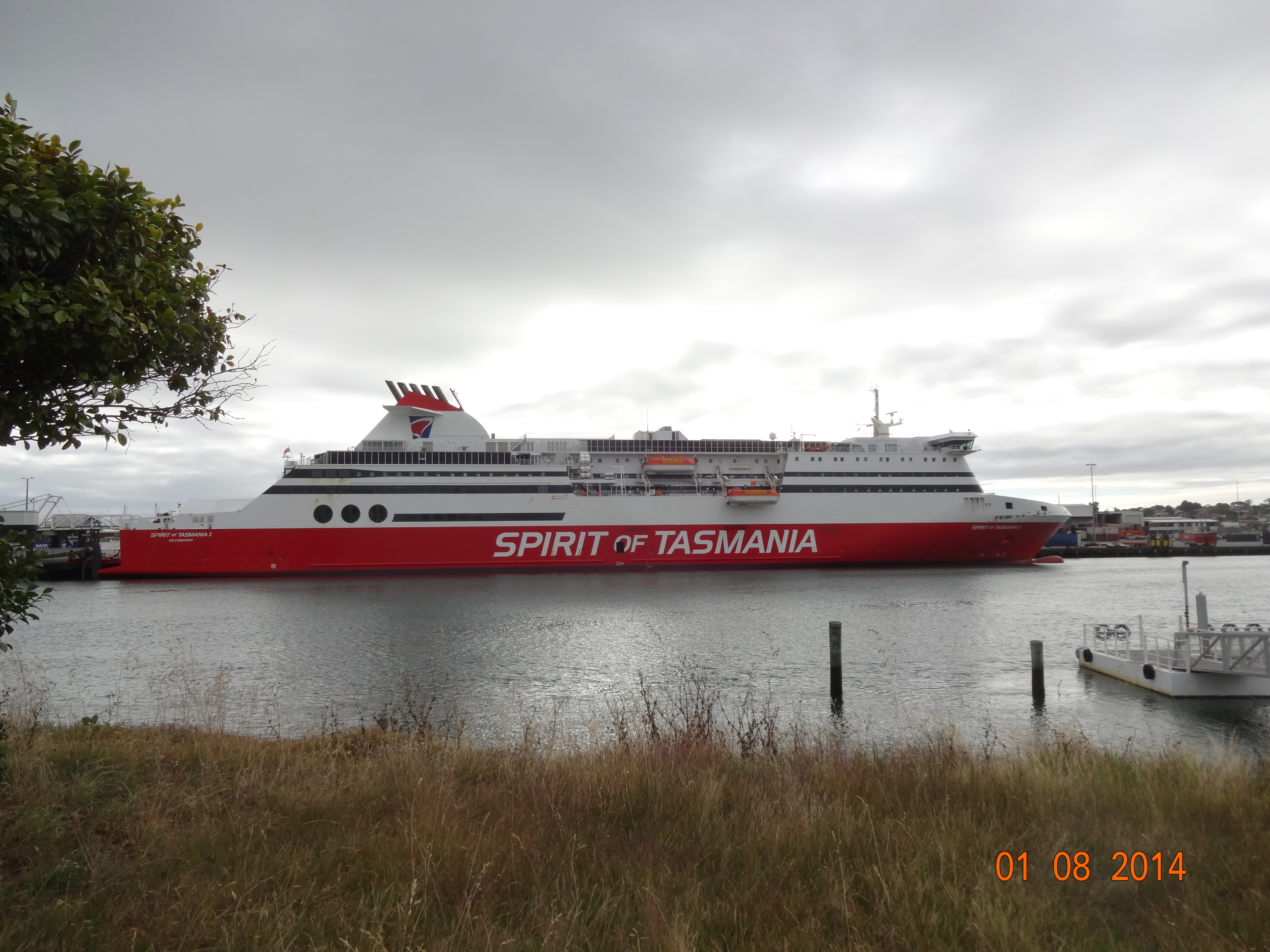
I took the Spirit of Tasmania from Melbourne to Devonport.  It is not the cheapest form of transport. I understand that this is an issue for the Tasmanian tourist industry.  There seems to be a simple answer – lower the prices.

Anyway the trip was comfortable and the meal on-board was good.

Railway Museum and Ride

I headed off west from Devonport.  I didn’t get too far before I stopped in a small own called Don.  The reason was that I saw a rail museum.  I am a bit partial to old railways.

This particular railway does not run far, however it is good to see that it still exists.

Ulverstone

I stopped in Ulverstone and checked into Furner’s Pub.  This was my first experience of a Tasmanian pub.  Unfortunately, it was to turn out to be typical of many of the pubs in the state.  It is really just a mini casino will lots of poker machines being played by some very sad people.  It is such a shame that so many of these places exist.

Along the Coast to Wynyard

The next leg was to Bernie via Penguin.  This is a very pleasant piece of coast line.  The narrow gauge rail line runs very close to the coast.  The line is still in operation for freight trains.  The passenger trains ceased operating over 20 years ago.  It is good that line is still in operation.  I guess that it possible that it sometime in the future, the passenger trains may be brought back into operation.

Burnie is not a very nice place.  It is industrial with a very large timber clip mill and loading facility.  I am not sure if that is really a long term business proposition.

On the way into Wynyard, I ran into a fellow cyclist – a bloke from Toronto.  He was somewhat mortified by the state of the roads.  This was to turn be a common view held by foreign cyclists I met on the trip.

Wynyard

I checked in the camping ground in Wynyard.  This is top spot.  I had a bit of difficult erecting my new North Face tent.  Once I finally got it erected, I was very satisfied.  It is an excellent tent.

A feature of the camping ground is the kitchen – it is excellent and has comfortable sitting room and television.  I decided to stay a couple of days.

Ride to Stanley

The ride west from Wynyard was pretty steep.

I had been told about a place called Port Harbour.  It turned to be a very pretty place – pure white sand and azure sea.  There not too many people in the water.  I soon found out the reason why – the water was bloody freezing.

The local Surf Club was serving fish and chips.  I had a great lunch and ended up having some long chats with a number a people who were fascinated with the setup of the bike – notably that back wheel.

After lunch I headed west to Sisters Beach which is in National Park.  It was worth the visit albeit it necessitated doubling back on the same road – I hate having to do that.

As I headed west I could see the ‘Nut’ which is where my destination, Stanley is located.  The ‘Nut’ is what remains of a volcanic plug.  The volcano is long gone.  It seemed to take forever before I made it to the turn off to Stanley.

I checked into the camping ground, set up the tent (in minutes this time) and headed up to pub for a beer and a meal. The food was great and the Kentish Ale was excellent.  I was to learn more about this ale later.

Stanley is a very pretty little town.  It is famous for being the home of Joseph Lyons, a former Prime Minister.  His cottage is a tourist attraction.  It is also known for its lobsters.

The next day I ran into a very attractive women taking photographs  with a camera with a very large lens.  She told me that she was a professional photographer, doing a assignment for a country life magazine.

I walked up the Nut via the Zig Zag track.  This is a must if you visit Stanley, don’t take the chairlift unless you are really unfit.

That night I ran into photographer  again in the pub.  During the day I had noticed that the War Memorial in town had the dates of WW1 as being 1914 to 1919.  I checked out the internet to find out why.  See the URL http://www.anzacday.org.au/education/tff/memorials/tasmania.html

The pretty photographer did not seen to be overly impressed with by local knowledge.

Off to Smithton

I headed out of Stanley via an old farmhouse situated above the town.  As I rode slowly up the hill a 4WD bleeped its horn as it came towards me.  Short time later the same vehicle passed me from behind and stopped ahead.

It turned out to be the photographer.  She told me that she was heading back to Nut to take some more photos as “the light was really good”.

I told that one look at the Nut was good enough for me.  She said “that was a pity as it was a chance to take a picture of two Nuts”.  She giggled, said “see ya” and roared off down the hill.

The farmhouse was established by the Van Diemen’s Land Company in the 1860’s.  Apparently the plan was to grow sheep on the land.  They invested millions of $’s in today’s money on what turned out to be a failed venture.  The sheep died on the cold and wet weather.  That seems to be a bit odd given sheep live, and apparently prosper, in places like the Outer Hebrides in Scotland.

Smithton

I stayed in Smithton and won’t do that again.

To Arthur River

Leaving Smithton, I rode west  towards Woolnorth.  The wind was behind me and I made surprisingly good progress.

Woolnorth is another of the properties developed by the Van Diemen’s Land Company.  It is now owned by a New Zealand Diary Company and by all accounts they are doing very well.  Cows must be tougher than sheep.

Short of going right into Woolnorth, I headed south on dirt road to Marrawah.

I stopped in the Marrwah Tavern for a late lunch and beer.  I chatted to two blokes from Melbourne that had walked up the coast, mainly on the beach, from Zeehan.  That must have been some walk.

The barmaid in the Tavern told me that there was nowhere to buy alcohol in Arthur River.  She asked me what I would like her to take to the shop down there for me to collect later.  She told me that she lived in Arthur River and “this was a service she offered to cyclists and walkers that were heading that way”.  There seemed  to be no question as to whether I wanted  to buy something – that was simply assumed.   I bought a bottle of red wine.

Arthur River

I check into the Arthur River camping ground which is about 2.5 klms out of town.  It seemed to be a very strange place to locate the place.

I then headed into the town for a ‘Hamburger with the lot’, at one of two small shops.  The other one was closed.  The choice of meals was what I ordered and a Hamburger with ‘less than the lot’.

The bottle of red tasted remarkable good.  I guess everything is relative.

It was a very wind night in the tent.  It look it very well.

The next morning I headed back into to town to take the Arthur River cruise.  The boat is owned and operated by a bloke called Gagy.  His off-sider is character named Mouse. There was about 20 people booked for the trip – mainly people of my vintage with one young family.

We headed up the river and Gagy and Mouse told us about the wildlife and the history of the river.  At one point we stopped to feed two sea eagles that swooped down to collect some fish that Mouse through on the river bank for them.  Apparently there are two schools of thought regarding whether you should feed wild birds.  I suspect two small fish once a day at most, isn’t too bad.

We stopped for lunch about 14 klms up the river.  Before lunch Mouse took us for a short walk into the bush.  It is incredibly dense.   Many of the trees are many hundreds of years old.  This an area that the Abbott government is proposing to remove from the Heritage listing and thereby allow logging.

After lunch we head back down the river.  Gagy let most of the passengers have a go steering the boat.

We got back to the town in the late afternoon.  This gave me time to head out to a place called the ‘End of the Earth’. This is the most westerly point in Tasmania.  It is aptly named.  If you travel due west, you would come to Argentina – missing the southernmost point of Africa.   Put that in your trivia file.

South and East

I got up reasonably early to head back to Stanley.

At one stage I had thought of taking the road that goes to Corrinna, however this has been washed out in a section and is closed to vehicular traffic.  It is possible to ride a bike through the closed area, however, the local police advised not to do it alone.

I rode south into what seemed to be a gale.  I stopped briefly at place called Cuta Rocks  where I had a conversation with some locals.  I made a comment about the extraordinary strength of the wind.  The response was:  “yeah it’s a bit breezy” .  I would hate to see when it is more than “a bit breezy”.  It would be impossible to ride in those conditions.

As I turned east and headed inland the wind finally dropped.

After a long day in the saddle I finally made it back into Stanley.

Bus to Devonport

I had decided to take the bus back Devonport on account that I cannot abide doubling back on the same roads I have already ridden on.

This meant staying another day in Stanley.  The photographer was nowhere to be seen.  I did however, have opportunity to get a very cheap haircut from a girl called Ashlee, who operated her business in shed in her backyard.  When I looked at the result in the mirror I thought $20 was probably too much to pay.

Next morning I caught the bus to Burnie with an onward connection to Devonport.

Flickr Link

http://flic.kr/s/aHsjQmogYi

Garmin Links

http://connect.garmin.com/activity/426901905

http://connect.garmin.com/activity/427013713

http://connect.garmin.com/activity/428569499

http://connect.garmin.com/activity/430253218

http://connect.garmin.com/activity/431101235